A Walk in the Dolomites
Introduction
Friday - San Candido Circuit
Saturday - San Candido to Rifugio
Sunday - Rifugio to Misurina
Monday - Tre Cime Circuit
Other Stuff
Tuesday - Citta di Carpi Circut
Wednesday - Val d'Ansiei to Cortina
Sunday - Rifugio to Misurina
This was the most memorable day of the walk and also the most difficult. The difficulty came, not in going up, but in coming down! In particular the descent from the Passo Grande dei Rondoi was steep, over loose scree and slippy. The slippiness was due to a change in the geology. At the col we moved from massive dolomite to more finely bedded shales and dolomites. This made ones footing rather more precarious. Quite often you had to ignore the scenery to look at where you were putting your feet!
But the difficulties were overcome and what I remember is the magnificent scenery. I hope I captured some of that in the following photos.
The change in geology at the col supports the interpretation of the geology of the Dolomites as a group of atolls in a Triassic sea. The steep, sea facing, part of the atolls was comprised of coral which became hard limestone. The inward, lagoon part had more varied rock types. At the Passo Grand dei Rondoi we move from the limestone of the seaward facing part of an atoll to the shales and limestones of the lagoon. This is repeated many times in the Dolomites. The peaks and ridges are the outside of the atolls, the lower ground the interior lagoons.
There is much more to the geology of the Dolomites than this but it is enough for now! And we have not seen any explanation for the conversion of coral limestone (calcium carbonate) into dolomite (calcium magnesium carbonate). We know it happened, we do not know how it happened.
Our route (the BLUE line) compared to the On Foot Holidays suggested route (the RED line). The numbers are where the photos were taken (approximately!). The strange divergence just south of the Rifugio may be due to reflected signals. We certainly did not walk there.
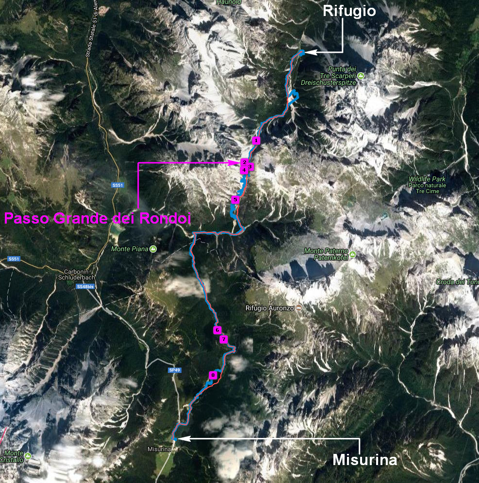

Photo 1:- The path across the scree on our way up to the Passo Grande dei Rondoi.

Photo 2:- The view southwards at the Passo Grande dei Rondoi. Peaks everywhere. And note the shaly bands in the dolomite.

Photo 3:- A panorama looking southwards just below the Passo Grande dei Rondoi.

Photo 4:- Chris descending, carefully, from the col.

Photo 5:- Coming down the less steep part of the descent.
Once we had got to the bottom of the descent we discussed whether we should abandon the rest of the walk and head to the Tres Cime Hotel and get a taxi to Misurina. But even the most tired of us decided that we would complete our route. If we could defeat the descent from the col we could get to our destination on our own feet!
And the scenery we saw made the decision the right one.

Photo 6:- Alpine meadows and dramatic peaks.

Photo 7:- More alpine meadows and dramatic peaks.

Photo 8:- View across the Lago Antorno.
At last we got to the Hotel Lavaredo. We showered and had a rather good supper. It had been a very satisfying day.
---------------------------------------------------------------------------------------
All of this days photos can be found HERE.
And here are today’s distances walked and heights climbed. My distance walked probably indicates a lot of toing and froing on the descent from the col.
| Sunday | Distance | Height Gained |
|---|---|---|
| On Foot's Figures | 16km | 1020m |
| My GPS | 27.9km | 1167m |
Introduction
Friday - San Candido Circuit
Saturday - San Candido to Rifugio
Sunday - Rifugio to Misurina
Monday - Tre Cime Circuit
Other Stuff