WEGA in the North West United States
May 29th to June 11th 2016
Return to "Day" page
Geological Background
The Western Cascades (continued)
The Western Cascades formed during two episodes of volcanism from 35 – 18 Ma and 14 – 8 Ma, separated by an interval of relative uplift and erosion with little volcanic activity. Convergence rates were high during these periods, indicated by the formation of a fairly low and broad volcanic arc containing copious amounts of volcanic rocks produced by high rates of volcanism (as much as triple the present rate). Convergence rates between the Juan de Fuca plate and the North American plate decreased significantly between about 9 and 7 Ma, accompanied by a steepening of the convergence angle and a shortening of the convergent margin as the Pacific – North American plate transform boundary migrated northward. The combined result of these factors was the eastward migration and narrowing of the older volcanic arc and formation of the High Cascades volcanic arc. Subsequent growth of the High Cascades from about 7 Ma to the present was accompanied by extension and thinning of the overlying North American plate and formation of a major N-S trending graben, subsequently buried by the eruptive products of the High Cascades volcanoes, a corresponding increase in mafic volcanism (although some silicic centres remained active), and further uplift of the Western Cascades
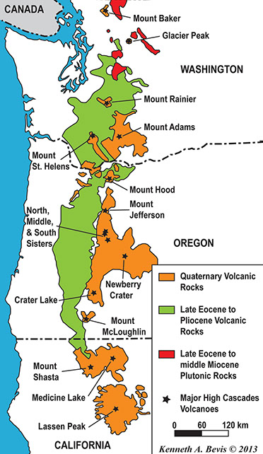
The High Cascade volcanic arc includes nearly 20 major volcanoes, among a total of over 4,000 separate volcanic vents including numerous stratovolcanoes, shield volcanoes, cinder cones, and lava domes. Although volcanism associated with the Cascade Range began about 37 Ma, most of the present volcanoes are < 2 Ma, and the highest peaks are less than 100,000 years. Twelve stratovolcanoes in the High Cascades province are over 10,000 ft. Newberry Volcano, a shield volcano and by volume one of the largest of the Cascade volcanoes is formed of over 108 mi³ of material.
Mount St Helens
The volcano was named by George Vancouver in 1792 for Baron St Helens, an English nobleman. After being dormant for 123 years, a series of earthquakes on March 20, 1980 marked its reawakening. A phreatic (steam) eruption took place on March 27, and then followed two months of earthquake and mild steam eruptions before the cataclysmic eruption on May 18, 1980 at 08:32. The eruption was characterized by a huge landslide (debris avalanche), an explosive lateral blast, many pyroclastic flows and volcanic debris flows and mudflows (lahars) along river valleys and a huge tephra plume injecting ash into the stratosphere for more than nine hours. The pre-eruption elevation in 1979 was 9,677’, and is now 8,365 after the eruption in which 57 people were killed. The eruption blast devastated an area of 230 square miles, with the eruption column reaching 16 miles in height, while the main avalanche extended for 15 miles and had a volume of 0.7 cubic miles. Mudflows/lahars travelled 75 miles along the Columbia river. The crater formed in the eruption is 1.5 x 1 miles and 2,000 feet deep, within which a new lava dome has developed. This dome grew in pulses from October 1980 to October 1986; in 1992 it was about 1,000 feet high.
All of what is written in the section above comes from Doug Robinson's handout but some of that cannot be easily cut and pasted so the next section comes from the Wikipaedia entry on the 1980 eruption. For ease of reading I have removed the references. If you want them, see the original entry.
On May 18, 1980, a major volcanic eruption occurred at Mount St. Helens, a volcano located in the state of Washington, United States. The eruption (a VEI 5 event) was the only significant volcanic eruption to occur in the contiguous 48 U.S. states since the 1915 eruption of Lassen Peak in California. The eruption was preceded by a two-month series of earthquakes and steam-venting episodes, caused by an injection of magma at shallow depth below the volcano that created a huge bulge and a fracture system on the mountain's north slope.
An earthquake at 8:32:17 a.m. PDT (UTC−7) on Sunday, May 18, 1980, caused the entire weakened north face to slide away, creating the largest landslide ever recorded. This suddenly exposed the partly molten gas- and steam-rich rock in the volcano to lower pressures. The rock responded by exploding a hot mix of lava and pulverized older rock toward Spirit Lake so fast that it overtook the avalanching north face.
An eruption column rose 80,000 feet (24 km; 15 mi) into the atmosphere and deposited ash in 11 U.S. states. At the same time, snow, ice and several entire glaciers on the volcano melted, forming a series of large lahars (volcanic mudslides) that reached as far as the Columbia River, nearly 50 miles (80 km) to the southwest. Less severe outbursts continued into the next day, only to be followed by other large, but not as destructive, eruptions later that year.
Approximately fifty-seven people were killed directly, including innkeeper Harry R. Truman, photographer Reid Blackburn and geologist David A. Johnston. Hundreds of square miles were reduced to wasteland, causing over a billion U.S. dollars in damage ($2.89 billion in 2015 dollars), thousands of game animals were killed, and Mount St. Helens was left with a crater on its north side. At the time of the eruption, the summit of the volcano was owned by the Burlington Northern Railroad, but afterward the land passed to the United States Forest Service. The area was later preserved, as it was, in the Mount St. Helens National Volcanic Monument.
Build-up to the eruption
Mount St. Helens remained dormant from its last period of activity in the 1840s and 1850s until March 1980. Several small earthquakes, apparently beginning on March 15, indicated that magma may have begun moving below the volcano. Then on March 20, at 3:45 p.m. Pacific Standard Time (all times will be in PST or PDT), a shallow magnitude 4.2 earthquake (the initial reading was 4.1), centered below the volcano's north flank, signaled the volcano's violent return from 123 years of hibernation. A gradually building earthquake swarm saturated area seismographs and started to climax at about noon on March 25, reaching peak levels in the next two days, including an earthquake registering 5.1 on the Richter scale. A total of 174 shocks of magnitude 2.6 or greater were recorded during those two days.
At 12:36 p.m. on March 27, phreatic eruptions (explosions of steam caused by magma suddenly heating groundwater) ejected and smashed rock from within the old summit crater, excavating a new crater 250 feet (75 m) wide[8] and sending an ash column about 7,000 feet (2,100 m) into the air. By this date a 16,000-foot long (4,900 m) eastward-trending fracture system had also developed across the summit area. This was followed by more earthquake swarms and a series of steam explosions that sent ash 10,000 to 11,000 feet (3,000 to 3,400 m) above their vent. Most of this ash fell between 3 and 12 miles (5 and 19 km) from its vent, but some was carried 150 miles (240 km) south to Bend, Oregon or 285 miles (459 km) east to Spokane, Washington.
A second, new crater and a blue flame were observed on March 29. The flame was visibly emitted from both craters and was probably created by burning gases. Static electricity generated from ash clouds rolling down the volcano sent out lightning bolts that were up to 2 miles (3 km) long. Ninety-three separate outbursts were reported on March 30, and increasingly strong harmonic tremors were first detected on April 1, alarming geologists and prompting Governor Dixy Lee Ray to declare a state of emergency on April 3. Governor Ray issued an executive order on April 30 creating a "red zone" around the volcano; anyone caught in this zone without a pass faced a $500 fine or six months in jail. This precluded many cabin owners from visiting their property.
By April 7 the combined crater was 1,700 feet long by 1,200 ft wide and 500 ft deep (520×370×150 m). A USGS team determined in the last week of April that a 1.5-mile-diameter (2.4 km) section of St. Helens' north face was displaced outward by at least 270 feet (82 m). For the rest of April and early May this bulge grew by 5 to 6 feet (1.5 to 1.8 m) per day, and by mid-May it extended more than 400 feet (120 m) north. As the bulge moved northward, the summit area behind it progressively sank, forming a complex, down-dropped block called a graben. Geologists announced on April 30 that sliding of the bulge area was the greatest immediate danger and that such a landslide might spark an eruption. These changes in the volcano's shape were related to the overall deformation that increased the volume of the volcano by 0.03 cubic miles (0.13 km3) by mid-May. This volume increase presumably corresponded to the volume of magma that pushed into the volcano and deformed its surface. Because the intruded magma remained below ground and was not directly visible, it was called a cryptodome, in contrast to a true lava dome exposed at the surface.
On May 7, eruptions similar to those in March and April resumed, and over the next days the bulge approached its maximum size. All activity had been confined to the 350-year-old summit dome and did not involve any new magma. A total of about 10,000 earthquakes were recorded prior to the May 18 event, with most concentrated in a small zone less than 1.6 miles (2.6 km) directly below the bulge. Visible eruptions ceased on May 16, reducing public interest and consequently the number of spectators in the area. Mounting public pressure then forced officials to allow 50 carloads of property owners to enter the danger zone on May 17 to gather whatever property they could carry. Another trip was scheduled for 10 a.m. the next day. Because that next day was Sunday, more than 300 loggers would not be working in the area. By the time of the climactic eruption, dacite magma intruding into the volcano had forced the north flank outward nearly 500 feet (150 m) and heated the volcano's groundwater system, causing many steam-driven explosions (phreatic eruptions).
North face slides away
As May 18 dawned, Mount St. Helens' activity did not show any change from the pattern of the preceding month. The rate of bulge movement, sulfur dioxide emission, and ground temperature readings did not reveal any changes indicating a catastrophic eruption. USGS volcanologist David A. Johnston was on duty at an observation post approximately 6 miles (9.7 km) north of the volcano: as of 6 a.m., Johnston's measurements did not indicate any unusual activity.
At 8:32 a.m., a magnitude 5.1 earthquake centered directly below the north slope triggered that part of the volcano to slide, approximately 7–20 seconds (about 10 seconds seems most reasonable) after the shock. The landslide, the largest in recorded history, travelled at 110 to 155 miles per hour (177 to 249 km/h) and moved across Spirit Lake's west arm. Part of it hit a 1,150-foot-high (350 m) ridge about 6 miles (10 km) north. Some of the slide spilled over the ridge, but most of it moved 13 miles (21 km) down the North Fork Toutle River, filling its valley up to 600 feet (180 m) deep with avalanche debris. An area of about 24 square miles (62 km²) was covered, and the total volume of the deposit was about 0.7 cubic miles (2.9 km³).
Scientists were able to reconstruct the motion of the landslide from a series of rapid photographs by Gary Rosenquist, who was camping 11 miles (18 km) away from the blast. Rosenquist, his party and his photographs survived because the blast was deflected by local topography 1 mile (1.6 km) short of his location.
Most of St. Helens' former north side became a rubble deposit 17 miles (27 km) long, averaging 150 feet (46 m) thick; the slide was thickest at 1 mile (1.6 km) below Spirit Lake and thinnest at its western margin. Thousands of trees were torn from the surrounding hillside after the lake was sloshed 800 feet (240 m) up the hillside. All the water in Spirit Lake was temporarily displaced by the landslide, sending 600-foot-high (180 m) waves crashing into a ridge north of the lake, adding 295 feet (90 m) of new avalanche debris above the old lakebed, and raising its surface level by about 200 feet. As the water moved back into its basin, it pulled with it thousands of trees felled by a super-heated wall of volcanic gas and searing ash and rock that had overtaken the landslide seconds before. Three decades after the eruption, mats of floating or stranded trees on the nearby Spirit Lake, St. Helens Lake, and Coldwater Lake remained visible on Google Earth satellite images.
Initial lateral blast
The landslide exposed the dacite magma in St. Helens' neck to much lower pressure, causing the gas-charged, partially molten rock and high-pressure steam above it to explode a few seconds after the landslide started. Explosions burst through the trailing part of the landslide, blasting rock debris northward. The resulting blast laterally directed the pyroclastic flow of very hot volcanic gases, ash and pumice formed from new lava, while the pulverized old rock hugged the ground, initially moving at 220 miles per hour (350 km/h) but quickly accelerating to 670 mph (1,080 km/h), and it might have briefly passed the speed of sound.
Pyroclastic flow material passed over the moving avalanche and spread outward, devastating a fan-shaped area 23 miles across by 19 miles long (37 km × 31 km). In total about 230 square miles (600 km2) of forest was knocked down, and extreme heat killed trees miles beyond the blow-down zone. At its vent the lateral blast probably did not last longer than about 30 seconds, but the northward-radiating and expanding blast cloud continued for about another minute.
Superheated flow material flashed water in Spirit Lake and North Fork Toutle River to steam, creating a larger, secondary explosion that was heard as far away as British Columbia, Montana, Idaho and Northern California. Yet many areas closer to the eruption (Portland, Oregon, for example) did not hear the blast. This so-called "quiet zone" extended radially a few tens of miles from the volcano and was created by the complex response of the eruption's sound waves to differences in temperature and air motion of the atmospheric layers and, to a lesser extent, local topography.
Later studies indicated that one-third of the 0.045 cubic miles (0.19 km³) of material in the flow was new lava, and the rest was fragmented, older rock.
Lateral blast result
Everyone in the quiet zone could see the huge ash cloud that was sent skyward from St. Helens' northern foot. The near-supersonic lateral blast, loaded with volcanic debris, caused devastation as far as 19 miles (31 km) from the volcano. The area affected by the blast can be subdivided into three roughly concentric zones:
- Direct blast zone, the innermost zone, averaged about 8 miles (13 km) in radius, an area in which virtually everything, natural or artificial, was obliterated or carried away. For this reason, this zone also has been called the "tree-removal zone". The flow of the material carried by the blast was not deflected by topographic features in this zone. The blast released energy equal to 24 Megatons of TNT.
- Channelized blast zone, an intermediate zone, extended out to distances as far as 19 miles (31 km) from the volcano, an area in which the flow flattened everything in its path and was channeled to some extent by topography. In this zone, the force and direction of the blast are strikingly demonstrated by the parallel alignment of toppled large trees, broken off at the base of the trunk as if they were blades of grass mown by a scythe. This zone was also known as the "tree-down zone". Channeling and deflection of the blast caused strikingly varied local effects that still remained conspicuous after some decades. Where the blast struck open land directly, it scoured it, breaking trees off short and stripping vegetation and even topsoil, thereby delaying revegetation for many years. Where the blast was deflected so as to pass overhead by several metres, it left the topsoil and the seeds it contained, permitting faster revegetation with scrub and herbaceous plants, and later with saplings. Trees in the path of such higher-level blasts were broken off wholesale at various heights, whereas nearby stands in more sheltered positions recovered comparatively rapidly without conspicuous long-term harm.
- Seared zone, also called the "standing dead" zone, the outermost fringe of the impacted area, a zone in which trees remained standing but were singed brown by the hot gases of the blast.
By the time this pyroclastic flow hit its first human victims, it was still as hot as 360 °C (680 °F) and filled with suffocating gas and flying angular material. Most of the 57 people known to have died in that day's eruption succumbed to asphyxiation while several died from burns. Lodge owner Harry R. Truman was buried under hundreds of feet of avalanche material. Volcanologist David A. Johnston was one of those killed, as was Reid Blackburn, a National Geographic photographer. Robert Landsburg, another photographer, was killed by the ash cloud. He was able to protect his film with his body, and the surviving photos provided geologists with valuable documentation of the historic eruption.
Later flows
Subsequent outpourings of pyroclastic material from the breach left by the landslide consisted mainly of new magmatic debris rather than fragments of preexisting volcanic rocks. The resulting deposits formed a fan-like pattern of overlapping sheets, tongues and lobes. At least 17 separate pyroclastic flows occurred during the May 18 eruption, and their aggregate volume was about 0.05 cubic miles (210,000,000 m³).
The flow deposits were still at about 300 to 420 °C (572 to 788 °F) two weeks after they erupted. Secondary steam-blast eruptions fed by this heat created pits on the northern margin of the pyroclastic-flow deposits, at the south shore of Spirit Lake, and along the upper part of the North Fork Toutle River. These steam-blast explosions continued sporadically for weeks or months after the emplacement of pyroclastic flows, and at least one occurred a year later, on May 16, 1981.
Ash column grows
As the avalanche and initial pyroclastic flow were still advancing, a huge ash column grew to a height of 12 miles (19 km) above the expanding crater in less than 10 minutes and spread tephra into the stratosphere for 10 straight hours. Near the volcano, the swirling ash particles in the atmosphere generated lightning, which in turn started many forest fires. During this time, parts of the mushroom-shaped ash-cloud column collapsed, and fell back upon the earth. This fallout, mixed with magma, mud and steam, sent additional pyroclastic flows speeding down St. Helens' flanks. Later, slower flows came directly from the new north-facing crater and consisted of glowing pumice bombs and very hot pumiceous ash. Some of these hot flows covered ice or water which flashed to steam, creating craters up to 65 feet (20 m) in diameter and sending ash as much as 6,500 feet (2,000 m) into the air.
Strong high-altitude wind carried much of this material east-northeasterly from the volcano at an average speed of about 60 miles per hour (97 km/h). By 9:45 a.m. it had reached Yakima, Washington, 90 miles (140 km) away, and by 11:45 a.m. it was over Spokane, Washington. A total of 4 to 5 inches (100 to 130 mm) of ash fell on Yakima, and areas as far east as Spokane were plunged into darkness by noon where visibility was reduced to 10 feet (3.0 m) and 0.5 inches (13 mm) of ash fell.[22] Continuing eastward, St. Helens' ash fell in the western part of Yellowstone National Park by 10:15 p.m. and was seen on the ground in Denver, Colorado, the next day. In time, ash fall from this eruption was reported as far away as Minnesota and Oklahoma, and some of the ash drifted around the globe within about 2 weeks.
During the nine hours of vigorous eruptive activity, about 540,000,000 tons of ash fell over an area of more than 22,000 square miles (57,000 km²).[5] The total volume of the ash before its compaction by rainfall was about 0.3 cubic miles (1.3 km³). The volume of the uncompacted ash is equivalent to about 0.05 cubic miles (210,000,000 m³) of solid rock, or about 7% of the amount of material that slid off in the debris avalanche. By around 5:30 p.m. on May 18, the vertical ash column declined in stature, but less severe outbursts continued through the next several days.
Mudslides flow downstream
The hot, exploding material also broke apart and melted nearly all of the mountain's glaciers along with most of the overlying snow. As in many previous St. Helens' eruptions, this created huge lahars (volcanic mudflows) and muddy floods that affected three of the four stream drainage systems on the mountain, and which started to move as early as 8:50 a.m. Lahars travelled as fast as 90 miles per hour (140 km/h) while still high on the volcano but progressively slowed to about 3 miles per hour (4.8 km/h) on the flatter and wider parts of rivers. Mudflows from the southern and eastern flanks had the consistency of wet concrete as they raced down Muddy River, Pine Creek and Smith Creek to their confluence at the Lewis River. Bridges were taken out at the mouth of Pine Creek and the head of Swift Reservoir, which rose 2.6 feet (0.79 m) by noon to accommodate the nearly 18,000,000 cubic yards (14,000,000 m³) of additional water, mud and debris.
Glacier and snow melt mixed with tephra on the volcano's northeast slope to create much larger lahars. These mudflows traveled down the north and south forks of the Toutle River and joined at the confluence of the Toutle forks and the Cowlitz River near Castle Rock, Washington, at 1:00 p.m. Ninety minutes after the eruption, the first mudflow had moved 27 miles (43 km) upstream where observers at Weyerhaeuser's Camp Baker saw a 12-foot-high (4 m) wall of muddy water and debris pass. Near the confluence of the Toutle's north and south forks at Silver Lake, a record flood stage of 23.5 feet (7.2 m) was recorded.
A large but slower-moving mudflow with a mortar-like consistency was mobilized in early afternoon at the head of the Toutle River north fork. By 2:30 p.m. the massive mudflow had destroyed Camp Baker, and in the following hours seven bridges were carried away. Part of the flow backed up for 2.5 miles (4.0 km) soon after entering the Cowlitz River, but most continued downstream. After traveling 17 miles (27 km) further, an estimated 3,900,000 cubic yards (3,000,000 m³) of material were injected into the Columbia River, reducing the river's depth by 25 feet (8 m) for a 4-mile (6 km) stretch. The resulting 13-foot (4.0 m) river depth temporarily closed the busy channel to ocean-going freighters, costing Portland, Oregon, an estimated five million US dollars. Ultimately more than 65 million cubic yards (50 million cubic metres) of sediment were dumped along the lower Cowlitz and Columbia Rivers.