WEGA in the North West United States
Return to "Day" page
Return to Day 10 Page
Geological Background
CENTRAL ROCKY MT PROVINCE – WYOMING THRUST BELT
In traversing south and east from Washington State with its voluminous CRB, the Snake River Plain and the Yellowstone hot spot, the trip moves from some of the youngest Cordilleran Provinces into older and quite different tectonic provinces. Here the trip enters areas affected by the Sevier and Larimide orogenies.
There has been much confusion over the Sevier and Larimide orogenies because they overlap in time and location. The Sevier orogeny (140 – 50 Ma, Late Cretaceous climax, 70-65 Ma) started earlier, and then the later stages overlap with the Laramide orogeny (80/70 – 55/35 Ma, with a Paleocene climax 66-56 Ma) that developed in the Late Cretaceous and continued into the Oligocene. The two orogenies were the result of the same crustal shortening event involving collision of the Farallon and North American plates, but they are distinguished by style of deformation. The Sevier appears to be an expression of how the upper crust responded to the shortening driven by plate interactions at that time, while the Laramide orogeny may be an expression of how the deeper crust and underlying lithosphere responded to the same processes.
As a result of rapid subduction of the very large Farallon plate, and the accretion of large terranes throughout the Mesozoic, much compressional stress was generated in the crust over a large sector of western North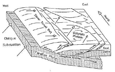 America, creating the thrust-faulted geological structures and resulting mountains of the Sevier orogeny. The Sevier orogeny is evident more in the western areas where it affects extensive and thick Palaeozoic and Mesozoic sequences that were deposited off the continental edge. The shortening (~125 miles) along weak shale and evaporite horizons, resulted in thrusts that often took advantage of weaknesses along bedding planes. Thus, this style of deformation affecting mainly layers of sedimentary rock in the upper crust is called "thin-skinned" tectonics.
In contrast, the Laramide orogeny is developed more towards the east where the sedimentary sequences overlying the continental edge were much thinner and did not easily decouple from the basement rock. Here the shortening was 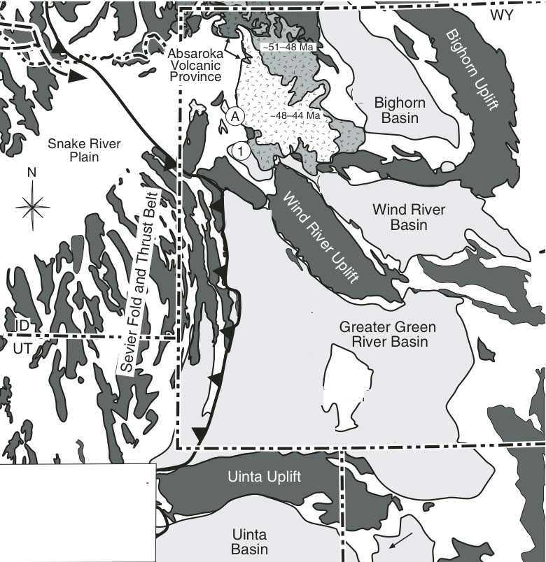 transmitted through the deeper crystalline rocks, causing thrust and reverse faulting in the basement and so forming “basement-cored” mountains – a style referred to as “thick-skinned” tectonics. The trends of these uplifted blocks can vary greatly, and this is probably the result of the reactivation of pre-existing heterogeneities in the basement rocks. An unusual aspect of the Laramide uplift is that the deformation occurred within the North America Plate rather than at the plate boundary.
The favoured model for the generation of these contrasting tectonic regimes is based largely on the evidence that close to the time of the Larimide climax (late Cretaceous), the subduction-driven volcanism moved far inland, which is consistent with a hypothesis that the fast-moving Farallon plate travelled far inland just beneath the base of the North American plate before it subducted – termed flat-slab subduction such as presently occurring under S. America. The lower angle of subduction resulted in the contractional forces being transmitted over a greater width than with respect to more steeply dipping subduction.
The major thrust-faulted mountain ranges of the Sevier orogeny built up high enough so that the crust further 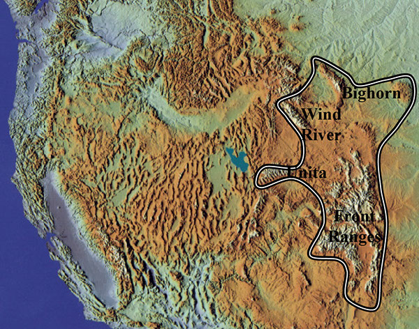 ahead (east) was loaded and became depressed into a basin - a process known as flexural subsidence. Sediment eroded from the elevated thrust mountain front provided debris to infill the basins, which were often of a lacustrine character. The combination of this flexural loading and the transmitted forces associated with the flat slab subduction gave rise to the Larimide foreland. From Late Cretaceous to Eocene time this foreland region was partitioned into a mosaic of uplifts and associated basins.
 Laramide structures were produced in central and eastern Utah, western Colorado, and most of Wyoming - thus, some overlap the eastern Sevier thrust belt structures. Classic Laramide structures in Utah include the Uinta Mountains uplift, the San Rafael Swell, and the Circle Cliffs. Some structures, such as the Uinta Mountains, were affected by both events.
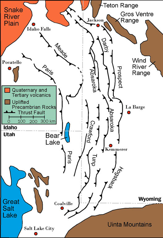
The Idaho-Wyoming thrust belt is a part of the Sevier event and contains folded and thrust sedimentary rocks. A series of westward dipping thrust faults transported parts of the Palaeozoic and early Mesozoic rocks about 100 miles eastward toward the continent during the late Cretaceous and early Tertiary times, during the Sevier orogeny. To the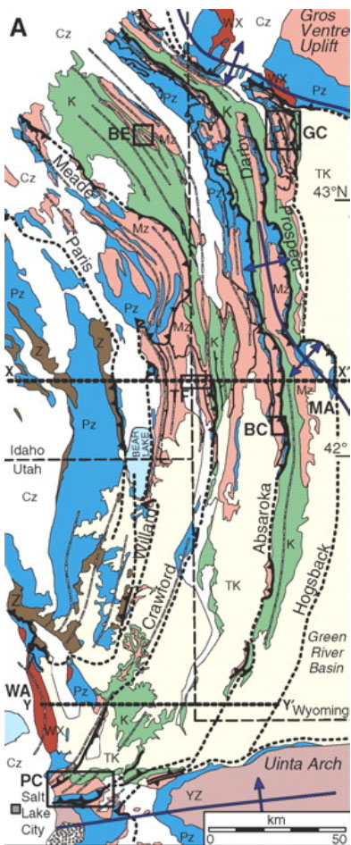 east, the thrust belt interacts with adjacent Laramide crystalline uplifts and distal foreland basins. Westward, the hinterland is more difficult to interpret because Tertiary normal faults of the Basin and Range province obscure the Mesozoic deformation. Eight major thrust belts make up the Idaho-Utah-Wyoming Fold Thrust Belt. In the east there are three thrusts: Absaroka, Darby and Prospect, which are dated as Absaroka (late Cretaceous 84-74 Ma), Darby (Paleocene 63-57 Ma), and Prospect (Eocene 57-52 Ma). These dates indicate that the westernmost thrusts moved first and subsequent movement proceeded sequentially eastward. The major thrust faults are listric in shape and join at depth to a low angle basal décollement, which is located at or above the basement-cover contact along much of its length within the Cambrian section. This detachment drops into the Precambrian section toward the hinterland.
Abutting the Idaho-Wyoming thrust belt to the east is the Green River Foreland basin. The Green River Formation represents a ~5 Ma interval of lacustrine deposition during the early to middle Eocene time. The basin is in the foreland of the Sevier Thrust Front and is bounded to the north, east, and south by Precambrian cored Laramide style uplifts from Cretaceous/Paleocene time.
The Green River Lake System covering part of Wyoming, Utah and Colorado was made up of three sub-tropical lakes namely, Fossil, Gosiute and Uinta.The original Fossil Lake was 40-50 miles long (N-S) and 20 miles wide, but varied considerably. One of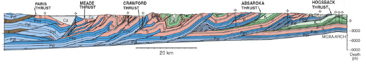 the lake formations is the Green River Formation, which preserve a wide variety of fossils, as preserved in Fossil Butte. In addition to the Green River Formation, the colourful Wasatch Formation, composed of river and stream sediments, is exposed in the national monument. The Wasatch Formation contains fossilized teeth and bone fragments of many Eocene mammal species, including early primates and horse, so adding a terrestrial component to the Fossil Butte story.
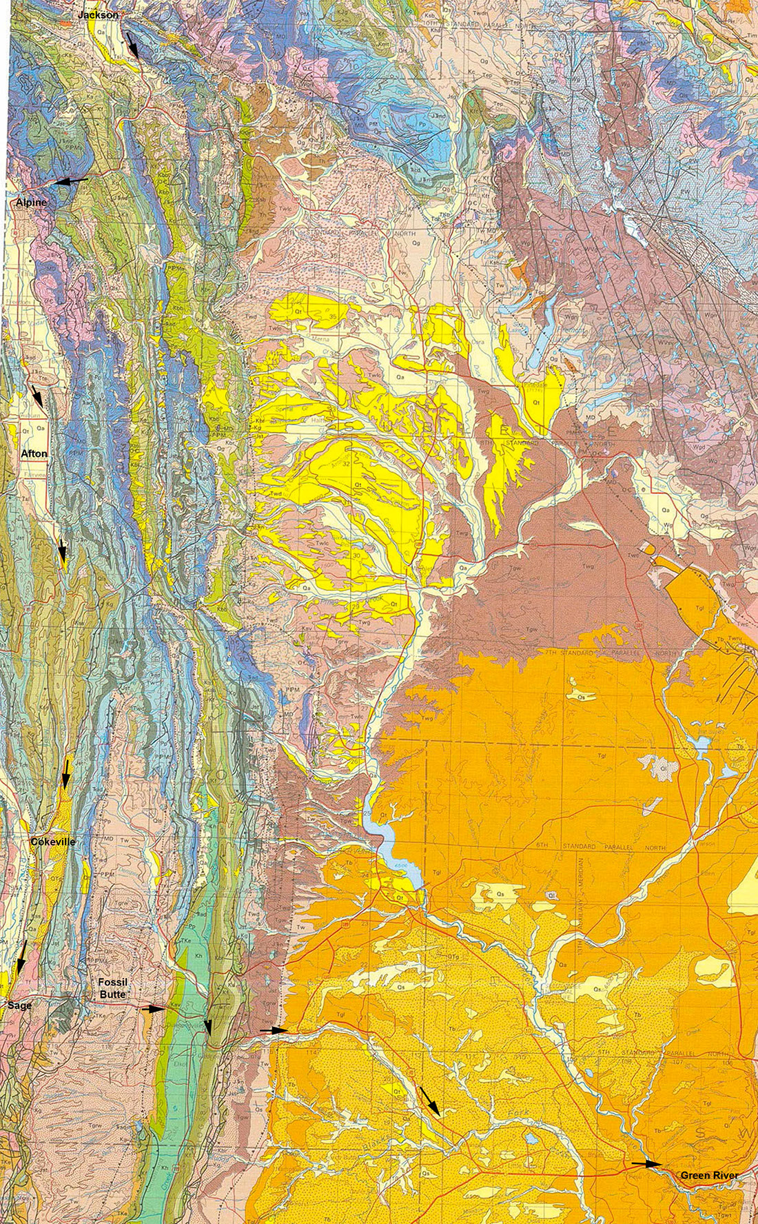
DAY 10 WYOMING THRUST BELT AND FOSSIL BUTTES
The town of Jackson lies on the easternmost edge of the Idaho-Wyoming thrust belt. The initial route south follows the Snake River and from the junction of US 89/191 crosses the NW-SE trending thrust Sevier ranges of Permian and Mesozoic rocks dipping west. After the Alpine junction US-89 follows the N-S trend of the Star Valley, which is a half graben structure bounded on the east by the Star Valley Fault. The salt river flows along the valley and there are salt deposits at the town of Auburn in the west of the valley. From about the town of Etna, the trend of the Salt River Range changes to a N-S strike. About 9 miles north of Afton the road passes through the “narrows” caused by two overlapping fault segments. Approaching Afton, one of the most prominent sections of the Star Valley fault scarps is visible to the east. The scarp has a height of ~ 40’ and displaces the small alluvial fans at the mouths of the creeks. (Best seen going short distance east along 2nd Ave). Earthquakes of magnitude 4.0 were recorded along this fault in 2010.
South of Afton the road climbs for 16 miles up to Salt River Pass at 7,610’. This pass was constructed in 1858 by the military and provided a shorter route to the Oregon territory and California, and was used by ~ 10,000 people. The ranges here are N-S and are mainly of Cretaceous age.
From a few miles north of Cokeville, south to Sage and then east to Fossil Butte the route is in Tertiary rocks forming the westernmost part of the Green River basin. East of Fossil Butte there is a N-S thrust belt of Cretaceous rock in the area of Kemmerer. The rest of the route to Green River remains in Tertiary rocks of the Green River Fm.
Fossil Butte has an Eocene sequence that is underlain by the slope-forming and variegated red and purple Wasatch Formation. The Wasatch Formation represents a vegetated, fluvial food plain that was crossed by numerous rivers and streams. The overlying Green River lake developed in three phases: a shallow freshwater phase (lower unit); a relatively deeper freshwater to saline phase (middle unit) and a mostly hyper saline-alkaline phase (upper unit).
Lower unit - the white cliffs of the Green River Formation contrast with the Wasatch units. At this time, the lake never attained depths greater than 4-5 m, and was hyper saline lake at least twice and probably totally desiccated as shown by the 2m beds of dolomite. The massive white limestones are heavily bioturbated as indicated by abundant trace fossils. Towards the top of the lower unit there is a 3-4 m thick sequence of alternating siliciclastic mudstones and laminated micrites. At Fossil Butte, the mudstones of this unit represent a pro-delta deposit. Only a few kilometres north of Fossil Butte, the Lake was replaced by a fluvial flood plain during this time.
Middle unit - marks a rapid change to a wet-humid period of high rainfall. This unit is rich in oil shales. The lower oil shale at the base of the middle unit was deposited as a result of the most expansive phase of the lake's history. A mudstone unit (coaly mudstone) rich in coalified plant material with a 2-3 cm thick coal at the top can be traced throughout the basin. This sequence is interpreted as being deposited in a lake undergoing a rapid transgression. The transgression appears to have been initiated abruptly during a single episodic event that transported huge amounts of plant material into the lake, resulting in the thin coal deposit. The high organic-carbon content and dense fossil fish concentrations are consistent with a lake in its early stages of expansion. Nutrient levels are high and are inherited from the rich soils recently flooded. The unit contains a well-preserved fossil fish fauna in an 18 inch layer.
Upper Unit - here the lake developed into a large, but shallow, hyper saline lake, generally devoid of fossils in central basin areas. Salt casts of sodium carbonate minerals are abundant indicating hypersalinity. A series of 3-4 oil shales (kerogen-rich laminated-micrite) within the lower half of the upper unit provide marker beds that can be traced throughout the basin. The top of the unit does contain many fish fossils and there is a mass mortality bird bed, with egg shell fragments, gastropods and ostracods commonly associated.
The Green River Formation is an assemblage of over 1,000 feet of sedimentary rocks that lie beneath parts of Colorado, Utah, and Wyoming that has the reputation for containing the world’s largest deposits of oil shale. The USGS estimates that the formation contains ~ 4 trillion barrels of oil, with half being recoverable, depending on available technology and economic conditions. In comparison, 1.5 trillion barrels of oil is about equal to the entire world’s proven oil reserves. Colorado alone contains about 1,300,000 barrels of oil per acre on average, making it the most oilrich deposit in the United States–and probably the entire world.
Many other shale formations in the US, such as in Dakota and Texas are seeing rising production from hydraulic fracturing, but the same trend has not been used in the Green River. In the Texas and Dakota deposits the hydrocarbon is trapped within shale formations as actual oil or gas, and cannot escape due to the low porosity/permeability of the host rock, and thus is termed tight gas. In the case of the Green River the rocks have not sufficiently matured (i.e. reached temperatures of 80°C +) and so the potential hydrocarbon occurs as solid and heavy hydrocarbon. Thus in order to obtain the oil it is necessary to excavate the rock and heat it to convert the hydrocarbon into liquid/gas, or introduce a heat source at depth to do the same process.
Return to Day 10 Page
May 29th to June 11th 2016