WEGA in the North West United States
May 29th to June 11th 2016

Day 11 - Wednesday 8th June 2016
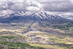
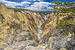
Our journey from Green River to Vernal was a very pleasant drive, mainly over relatively young rocks, but it did cross some older stuff when we got to the Uinta Mountains and the Flaming Gorge of the Green River. There were no "Must See" stops along the way but what we did see was well worth stopping for.

Along much of the route were roadside markers, giving some information about the geology. This is part of the reason for the route to be called the "Drive Through the Ages".

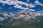
The group stops on the "Drive Through the Ages" to look at the rocks and the scenery
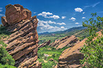
The rocks we were seeing were dipping north off the Uinta Mountains, so as we went south we came upon older rocks. See HERE. When we got to the Triassic we turned westwards into Sheep Creek Canyon where we would have the opportunity to see the contact of the younger rocks with the older uplifted Uinta rocks. More details HERE.

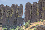
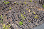
In Sheep Creek Canyon, looking at Permian (probably) Rocks

At our lunch stop, looking at Mississippian Madison Limestone, at the top of the cliffs, faulted against the red Pre-Cambrian rocks of the Uinta uplift.

Our lunch stop was a very pleasant place but it is not always so. We were there almost exactly 51 years after the flood this plaque memorialises. Later that day we met members of the families involved who were on their annual pilgrimage to the site.

Madison Limestone (Mississippian (Lower Carboniferous)) and younger rocks faulted against red Pre-Cambrian Uinta rocks

Panorama showing the younger rocks (on the right) faulted against the older rocks of the Uinta Uplift
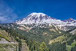
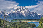
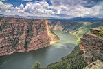
We continued our loop and returned to the main road driving south until we came to the side road leading to the Red Canyon Visitor Centre. This overlooks Flaming Gorge which is cut by the Green River into the flat-lying, red, Pre-Cambrian rocks of the Uinta Uplift. As almost everywhere in the western United States, if you see a river, a dam cannot be far away. The water you see is impounded by the Flaming Gorge Dam.
It would be interesting to see the gorge as a natural waterway. The original explorers, including John Wesley Powell, described it as being "a flaring, brilliant, red gorge that may be seen from the north a score of miles away" and named it Flaming Gorge. Powell canoed down Flaming Gorge on his expedition which included the Grand Canyon and recorded many rapids in the gorge. You can read his account HERE. Chapters V and VI cover the descent of Flaming Gorge. Some of his place names can still be found.

Flaming Gorge from the Red Canyon Visitor Center. The cliffs are said to be about 1,700 feet high, but that may be the depth to the valley bottom, not to the water level.

Panorama looking south from the Visitor Centre. Note the worrying crack on the right!

Panorama looking north from the Visitor Centre.

An interesting diagram found in the Red Canyon Visitor Center. Lots of water in a desert makes for a pleasant place to live. Note how much water gets to Mexico.

Flaming Gorge Dam completed in 1964
From the Visitor Centre we drove to Flaming Gorge Dam which is actually built in Red Canyon - Flaming Gorge is 20 miles upstream. You can find details of the dam HERE. Then onwards towards Vernal. A map of the geology we passed through can be seen HERE.
Our only stop was at a phosphate mine on either side of the road above Vernal.

The phosphate mine near Vernal.

WEGA in the North West United States