WEGA in the North West United States

Day 2 - Monday 30th May 2016
Our route for the day was through Mount Rainier National Park to Ellensburg. Mount Rainier (often pronounced rainier (as in rain) because it can be damp!) is a Quaternary volcano sitting on a basement of Miocene granodiorite. It may still be active - the last known eruption being sometime between 1820 and 1853. But there may have been an eruption in 1894. If Mt. Rainier were to erupt as powerfully as Mount St. Helens did in its May 18, 1980 eruption, the effect would be cumulatively greater, because of the far more massive amounts of glacial ice locked on the volcano compared to Mount St. Helens, the vastly more heavily populated areas surrounding Rainier, and the simple fact that Mt Rainier is a much bigger volcano, almost twice the size of St. Helens. Lahars from Rainier pose the most risk to life and property, as many communities lie atop older lahar deposits.
It is the highest mountain in the Cascades with an elevation of 4,392 m (14,411 ft). As we were to discover later that day, the Cascades form a barrier to wet winds blowing eastwards from the Pacific. Most of their rain falls on their western slopes and not much is left for the area to the east. One feels one has arrived in a different country when you get onto the high, dry, plains east of the Cascades.
After leaving the Interstate we travelled through countryside with lots of trees and hills. There were lots of saw mills and timber yards - lumberjack country. Then we got into the National Park where we started to see the really big trees. There has been no logging for more than a century in the park - and it shows!
We were gaining altitude as we crossed the Miocene granodiorite. Eventually we came to Christine Falls and had our first photo stop.


Christine Falls gets the photographic attention it deserves!
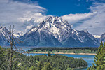
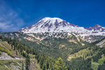
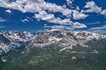
We then moved on to Ricksecker Point where we had good views of Mount Rainier. We were told that this is quite unusual. Many people have visited the park and never seen the mountain because of mist, clouds, rain, snow or other climatic phenomenon.

Mt Rainier from Ricksecker Point. The lower slopes are Miocene granodiorite, the cone is Quaternary volcanics. The granodiorite is glaciated, the volcanics post-date the glaciers. But there are small, mountain, glaciers on the cone.

Panorama of Mt Rainier from Ricksecker Point
We then moved on to Narada Falls. This is where the Paradise river flows over an andesitic lava flow. There is end-on columnar jointing which is believed to have formed by chilling of the lava against a glacier filling a former river valley.

Narada Falls with rainbow and columnar jointing
Also from the trail down to the falls we had a view of, what I believe is, Pinnacle Peak

Pinnacle Peak from the trail down to Narada Falls
After an abortive attempt to get to the Paradise Inn Visitor Centre - the car park was packed - we carried on to Inspiration Point. While waiting for all the cars to re-congregate - the roads are very windy with lots of junctions at which the correct direction is uncertain - I took yet another photo of Mt Rainier. the mountain and the weather were perfect.

Mt Rainier from Inspiration Point.
The next stop was at the Bench Lake pullout where we had views of Mt Rainier (again!), Stevens Canyon and Stevens Ridge. Here you can see the cone of Mount Rainier sitting on the peneplained Tatoosh (Miocene) granodiorite. Stevens Canyon is a glacial valley and Stevens Ridge consists of the granodiorite (the end nearest Mt Rainier) and welded tuff further away from the mountain.

The view from Bench Lake pullout. The granodiorite end just to the right of the highest point of Stevens Ridge
Our next stop was Box Canyon Overlook where there were two items of interest. The first was a roche moutonnée - a rock surface smoothed and rounded by moving ice. The down stream side is "plucked" by the ice and is roughened and cliff-like.
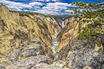
The second was the box canyon of the Muddy Fork, cut into the volcanic bedrock, forming a gorge 180 ft deep and less than 30 ft wide.
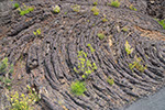
Our final stop was to look at the Colombia River Basalts with their characteristic columnar jointing, and here overlain by the Tieton andesite flow - the world'd longest andesite flow with a length of 49 miles from its source at Goats Rock volcano.
The Tieton andesite overlying columnar jointed Colombia River Basalts, on the banks of the Tieton river

After that it was along drive to Ellensburg. Compared to the green fields and forests of the western side of the Cascades, here we were in a dry, dusty, almost desert landscape.
All my photos of this days travels can be seen HERE. The days route and where the photos were taken can be found HERE. Download the file and open with Google Earth.
May 29th to June 11th 2016
Christine Falls - where Van Trump Creek crosses Paradise Road East

Roche moutonnée at Box Creek. Note the striations (scratches) which give the direction of ice movement. The ice moved from Mt Rainier. The plucked end of the roche is behind us.

The box canyon