WEGA in the North West United States
Return to "Day" page
Geological Background
COLUMBIA RIVER BASALTS (CRB)
The Columbia River Flood Basalt Province forms a plateau of 164,000 km2 between the Cascade Range and the Rocky Mountains, and has a volume of 175,00 km3. More than 300 individual large (average volume 580 km3) lava flows cover parts of Idaho, Washington and Oregon. In places, the lava pile is more than 3.5 km thick. About 85% of the province is made of the Grande Ronde Basalt with a volume of 149,000 km3 (which would bury all of the continental US under 12 m of lava!) that erupted over a period of < 1Ma. Flows erupted initially in the east, and then spread west to reach the Pacific Ocean, about 300 to 600 km from their fissure vents. The Pomona flow travelled from west-central Idaho to the Pacific (600 km), making it the longest known lava flow on Earth. Feeder dykes form the vents for the flood basalts, which trend NNW-SSE across eastern Oregon and western Idaho. Hundreds of vents have been recognized with some having spatter cone associated with the feeder dykes. The vents systems are 50 to more than 200 km long and a few kilometres wide. Most of the volume of the Columbia River Flood Basalt Province (85%) was erupted in the period from 17 to 15.5 million years ago.
The tectonic origin of the flood basalts has long been attributed to the initiation of a mantle plume whose present position is the Yellowstone hot spot. The main reason for this being the accepted model is that the very high magma supply over an extremely short geological period is not a feature seen in tectonic settings apart from plume types. The position of the initial fissure dykes lies at the tectonic boundary between terranes accreted during the Mesozoic made of thinner, denser oceanic lithosphere, and the more competent lithosphere of the continental North American Plate.
A second model envisages the flood basalts are linked to thinning of the lithosphere as a result of back-arc spreading behind the Cascade Arc. Recent refinement of this model depicts an episode of tearing of the subducting Farallon plate (slab breakoff) at about 17 Ma under eastern Oregon, leading to formation of a slab gap at shallow depth, which was then infilled by uprising mantle accompanied by decompression melting. This tear ruptured quickly north and south within about two million years covering a distance of around 900 km. This tear would be consistent with the occurrence of major volcanic dykes during the SCR–Northern Nevada Rift flood basalt event both in space and time.
The area and volume of the Columbia River Flood Basalt Province are impressive, but the volume is one-tenth that of other large igneous provinces such as Deccan, Parana, Karoo and the Siberian Traps
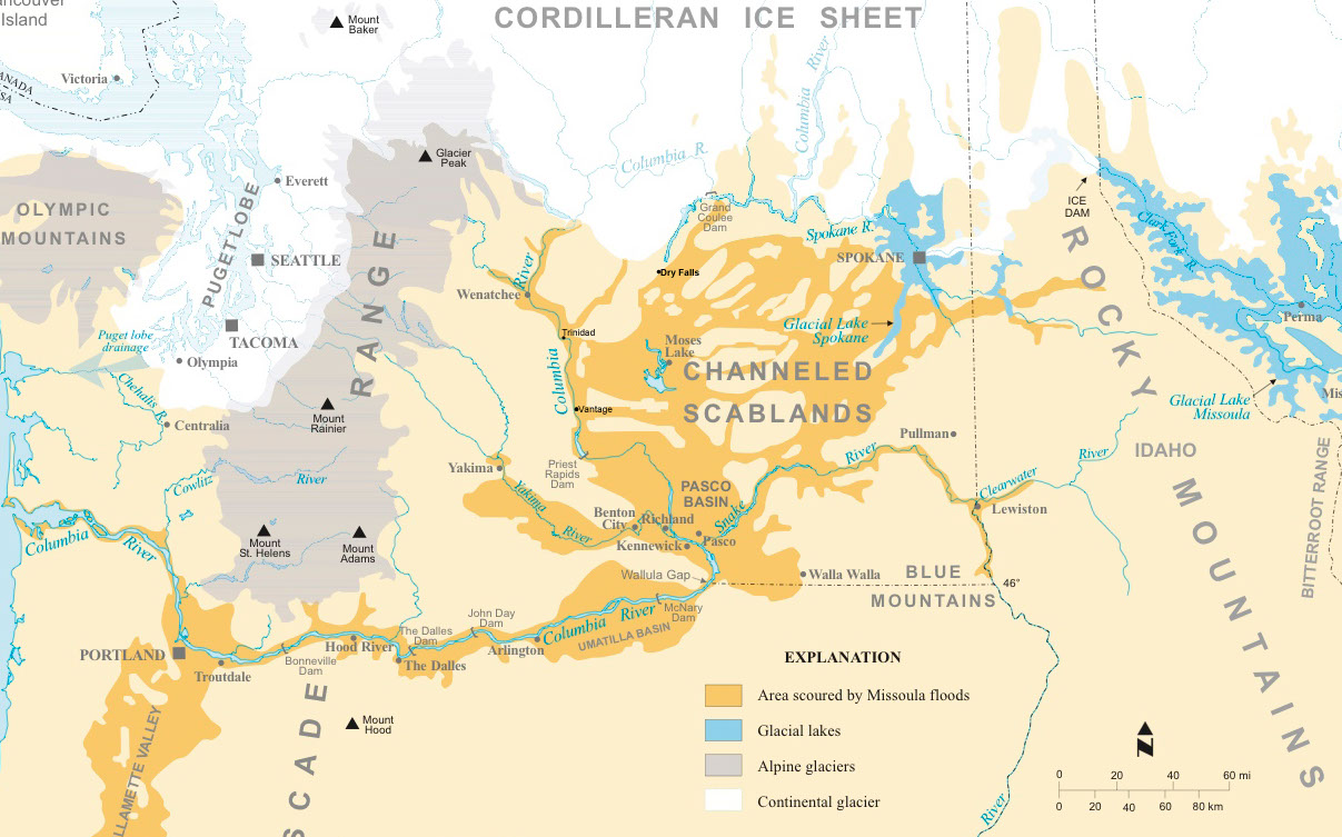
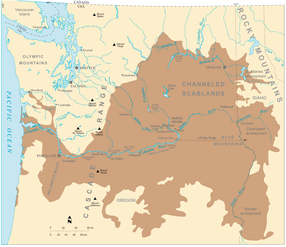
CHANNELLED SCABLANDS
Between 2 and 2.5 million years ago massive ice sheets formed and repeatedly advanced and retreated as climate conditions fluctuated. Ice coated the Puget Sound lowlands, and most of the mountain regions of northern Washington, Idaho and Montana. So much glacial ice existed that the oceans were 300 feet lower than they are today. As the ice sheets pushed southward from Canada they interrupted normal stream flows in the deep valleys of the mountainous Pacific Northwest. One protrusion, the Okanogan Lobe, created Lake Columbia. An ice mass clogging the Purcell Valley in Idaho blocked the outflow of the Clark Fork River, forming Glacial Lake Missoula. Other impoundments included a lake near Spokane.
The ice blockage in the Purcell Valley gradually backed up tremendous volumes of water in the deep valleys of western Montana, creating a gigantic reservoir, which attained a depth of 2,000 feet and impounded over 500 miles3 of water. The natural ice dam periodically failed, which caused a catastrophic emptying of Lake Missoula. After each dam failure, the southward moving ice sheet then created a new one, and the cycle repeated itself. At least 40 major flood episodes originated from Lake Missoula. Each ice dam failure released a torrent of water hundreds of feet deep, which swept southwesterly and gouged the huge coulees of eastern Washington, ripping out sediment and basalt rock, and stripping soil and vegetation from thousands of square miles of land in the Columbia Basin. Some of the debris was carried by the floods all the way to the ocean. One flood pathway created the Grand Coulee. A second poured into the lowlands around Ephrata, Moses Lake and Othello. A third flowed along the western fringe of the Palouse Hills, removing vast amounts of fertile topsoil. More than 2,000 miles² of so-called scablands were created as a result of this flooding.

Many of the flows in the Columbia River Flood Basalt Province show remarkable similarity. Most flows consist of colonnade (base), entablature (middle), and a vesicular and scoracious top.
The colonnade is caused by slow cooling of ponded lava.
Entablature is probably the result of cooling caused by water seeping into the fresh lava and causing rapid cooling from the surface downward.
The division between colonnade and entablature is the result of slow cooling from the base upward and rapid cooling from the top downward.
PPC – pillow palagonite (hyaloclastite) breccia complex, which forms where the base of a flow enters water. Spiracles are vents created where steam explosions occur at the base of flows.
May 29th to June 11th 2016
Return to Day 3