WEGA in the North West United States
May 29th to June 11th 2016
Day 3 - Tuesday 31st May 2016
The focus of this days geology was the Columbia River Basalt and the Channelled Scablands.
The Columbia River Basalt (or CRB) is a flood basalt and is an enormous volume of lavas - 174,300 km³ or 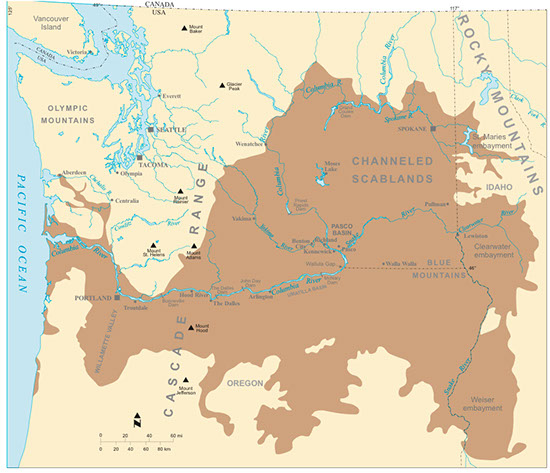 41,800 cubic miles! The movement of so much material from the sub-surface to the surface led to the sinking of the previous land surface and the development of the Columbia Basin. As a result the lava pile is more than 3.5km thick in places. Most of the basalt erupted between 17 and 15.5 million years ago.
There are two main theories concerning the formation of the CRB. One posits a mantle plume, which is now below Yellowstone. The other involves crustal thinning as a result of back-arc spreading behind the Cascade Arc. A discussion of this can be found in Doug's geological notes and these can be found HERE.
The Channelled Scablands are an area much affected by catastrophic flooding caused by the periodic failures of ice dams holding back huge volumes of water. This occurred when ice sheets pushing south from Canada disrupted the the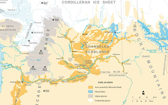 normal stream flows. In particular the Clark Fork River, a tributary of the Priest and, eventually, the Columbia River, was blocked by an ice dam. A huge volume of water built up behind this dam - figures of 500 miles³ are mentioned. And it goes by the name Glacial Lake Missoula.
The ice dam failed, and after each failure reformed, until the end of the Ice Age. And there were many failures, maybe as many as 40. Each failure released a torrent of water hundreds of feet deep, which swept in a southwesterly direction towards the sea. It gouged the huge coulees of eastern Washington, ripping out sediment and basalt rock, and stripping soil and vegetation from thousands of square miles of land in the Columbia Basin. You can get more information HERE.
That was the overall picture; the details are what follows.
We set out from Ellensburg and headed east to the Columbia River which like almost every river we saw on the trip was dammed, here by the Wanapum Dam. In the drier parts of Western USA there is a loathing for letting water "go to waste". So dams are built in every conceivable location irrespective whether it is a good idea or not.
We stopped at the Ginkgo Petrified Forest Interpretive Center but at this time of year it is closed on Tuesdays. However there were many petrified logs about the place and we were able to take a few photos.
The Columbia River at Ginkgo Petrified Forest; looking over Wanapum Lake at the lava flows of the Columbia River Basalts
Petrified tree at the Ginkgo Petrified Forest
Nearby there is a shop - the Ginkgo Gem shop - which was open and I bought a polished slab - shown below - of petrified sequoia. In this area the petrifying solutions come from the basalts and are mostly silica rich. So the result is a grey / white petrified log, unlike the reddish / orange logs we found in Arizona.
Dougs notes tell us:-
In the Miocene Period (~15 Ma) the region was wet and humid, dominated by swamps and shallow lakes surrounded by forests. Trees such as swamp cypress grew on the edges of the lakes, while deciduous trees (ginkgo, maple, walnut, oak, sycamore and horse chestnut) on the hillsides. Higher elevations supported thick stands of douglas fir, hemlock and spruce. The petrified trees in the Ginkgo Forest consist of all these trees, and they occur askew with no roots and branches. This suggest that the trees were not petrified in situ, but had been uprooted and transported into an area where they were later petrified. This might have taken place by the trees being stripped and transported by a volcanic blast into a lake, such as happened with the Mt St Helens eruption, or alternatively by a severe flooding event. Later the area was engulfed by one of the Columbia basalt flows, but the trees being water logged did not combust but became entombed. Circulation of silica-saturated waters, perhaps driven by the cooling flows, resulted in the petrifaction of the wood. The ice age Missoula floods then eroded the thick flows to reveal these petrified trees.
Cut and polished, petrified Sequoia from the shop near the Ginkgo Petrified forest Interpretive Center, Vantage, Washington
We then drove to Frenchman Coulée which is a dual coulee and cataract system created by the floods when they spilled westward over the Evergreen Ridge, out of the southwest corner of the Quincy Basin. During the initial flooding, the difference in water levels between the flood-filled Quincy Basin and the Columbia River immediately west of Evergreen Ridge was ~ 700’ over just a few miles. This incredible difference caused floodwaters to relentlessly eat away the underlying rock. Erosion continued for at least as long as it took for the water level in the Columbia Valley to rise to about 1200 feet, or until the floodwater supply was exhausted.
View down Frenchman Coulée. You can appreciate the depth and width of the valley. It was eroded by flood waters racing towards the Columbia river at the end of the coulée.
Panorama of Frenchman Coulée. The flood waters came from the right and went across the panorama to the Columbia River at the end of the coulée.
We then drove to Trinidad where we could look across the Columbia River and see the extraordinary giant ripples of the West Bar.
Giant current ripples at West Bar. The ripples average 24 feet in height and are 360 feet apart and composed of boulders up to 4.5 feet in diameter. Based on ripple size and spacing, it is estimated that the flood waters were about 650 feet deep when they formed.
Our next and final stop was Dry Falls State Park. The Dry Falls are a 400’ high scalloped precipice extending for 3.5 miles, five times the width of Niagara Falls, over which it is estimated the water flowed at 65mph. The undulating surface along the top of the cliff represent a series of channels where waterfalls once poured over the Dry Falls. Swirling currents at the base of the falls carved a basin that remains a natural lake at the base of the cliff.
The Dry Falls. The remnants of a series of waterfalls and plunge pools that formed from the Spokane Flood, a great flood that occurred at the end of the Pleistocene Epoch when the moraine dam of a huge lake collapsed. The flood occurred sometime between 18,000 and 12,000 years ago. The lake possibly drained in a matter of days or weeks, causing water to spread across the relatively flat Columbia River plateau before finding passage to the Columbia River.
Panorama of part of the Dry Falls. When flowing this may have been one of the most spectacular waterfalls of all time.
Here is a slideshow of all the photos I took on this day - 116 of them! If you wish you can sit through the whole slideshow or select the ones you want to look at more closely HERE. Also to see the route taken and where the photos were taken download THIS FILE and open it with Google Earth.
WEGA in the North West United States
