WEGA in the North West United States
May 29th to June 11th 2016
Return to "Day" page
Geological Background
The initial part of the route is across Quaternary sediments and volcanics, and from just before Pendleton on I84 it crosses onto the CRB. In the area around Baker City, I84 climbs into the Blue Mts, which is an inlier of 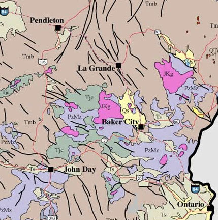 Palaeozoic and Mesozoic rocks that is part of the Baker
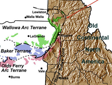 terrane. This was a subduction accretionary complex accreted to the western continental edge. Crossing into Idaho near Ontario the route is on mainly Quaternary sediments of the Snake River valley, with the Sawtooth Mts lying northeast being part of the massive Idaho Batholith The Idaho Batholith is a Cretaceous granite and granodiorite complex covering ~ 35,000 km2; it is roughly 320 x 120 km wide. There are the Atlanta and Bitterroot
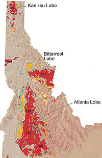 Lobes separated by Middle Proterozoic Belt Supergroup metamorphic rocks. The Atlanta lobe is older, 100 to 75 Ma, while the Bitterroot lobe is mainly 85 to 65 Ma. The complex is built up of multiple intrusions formed as a result of the massive Cretaceous subduction resulting in partial melting of the overlying mantle and then melting of the leading edge of the Precambrian continental edge.
Other Information
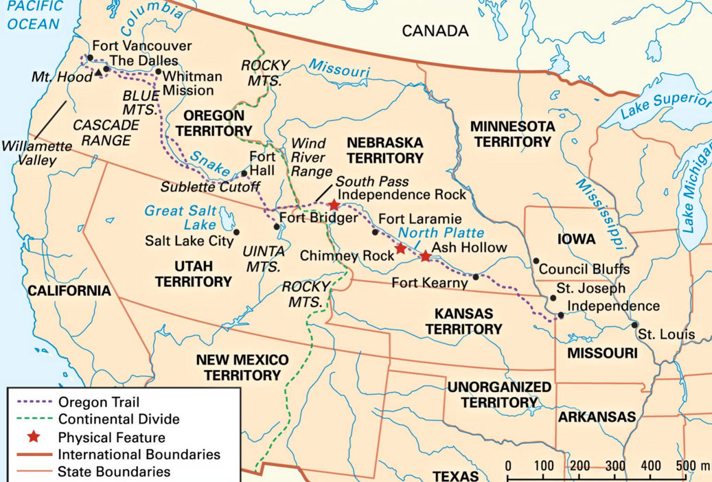
The route taken along I4 on Day 4, and then northeast along the Snake River Plain on Day 5 roughly follows the Oregon trail. This trail is a 2,200 mile, large-wheeled track that started in Kansas City and ended near Portland, and represents the first land route across the USA. The foundation for the route was started by the 1804-1806 Lewis and Clark expedition, which was charged with finding a water passage between the Missouri river and the Pacific ocean. Their outbound journey across the Rocky Mountains went through the Lemhi and Lolo passes which were
much too extreme to allow passage of wagon trains. Their return journey followed a faster and shorter route from the Columbia river southeast to the Snake River plain, although it was still very rough for wagons, and with the lands under the control of the Blackfoot tribe. Later exploration by mountain men and fur traders did eventually discover a better route across the Rocky Mts and the continental divide by finding South Pass, a “low” (7,412’) saddle in SE Wyoming. The epoch of this trail (and various offshoots) was 1846 – 1869, when it is estimated that some 400,000 people followed the trail. In places the trail is still marked by traces of thousands of wagon wheel tracks and animal hooves carrying the goods of the pioneers to the Pacific Northwest.
The Oregon Trail Interpretive Center features 12,000 square feet with life-size trail dioramas, replica wagons, and authentic artifacts, and the experiences of preparing for the journey, life on the trail, interaction between emigrants and natives, dangers and challenges, settlement and homesteading in Oregon. Photographs and artwork tell the story of the pioneers and the political and social background of the westward migration. Quotes pulled from the diaries of Oregon Trail emigrants are interwoven through the exhibit, using the words of the pioneers to describe the trek west.
There are approximately 13 miles of Oregon Trail wagon ruts along Virtue Flat that are visible from Flagstaff Hill. One mile of well-preserved ruts lie on the Interpretive Center grounds, and are accessible by the trails or from a turnout on Highway 86 about a half-mile west of the Center's entrance.