WEGA in the North West United States
Return to "Day" page
Geological Background
The Snake River Plain
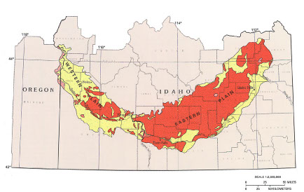 The Snake River Plain is an arcuate geological province stretching some 400 miles across southern Idaho. The western plain trends NW-SE and sits in a fault bounded basin infilled by rhyolitic tuffs and ash flows (15 to 11 Ma), and fluvial and lacustrine sediments with interbedded basalt flows dipping inwards towards the rift axis. Lake Idaho occupied this rift during the Pliocene.
The eastern Snake River Plain trends NE-SW but has no evidence of faulting along its margins even though the Basin and Range province borders its northern and southern margins. However its trend is oblique to the ~ N-S faults of the Basin and Range province. It is infilled by silicic (10-6 Ma) and overlying mafic volcanic rocks with local interbeds of continental sediments.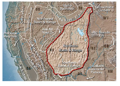 Quaternary basalt flows cover ~95% of the surface of the area.
The hotspot origin of the Snake River Plain is the most commonly accepted model, with the rapid eruption of the Columbia River basalts supposedly recording the initiation of the plume. The strongest line of evidence being the time transgressive record of silicic volcanism in the eastern part of the plain, interpreted to be the result of the movement of the North American Plate over the stationary Yellowstone mantle plume. 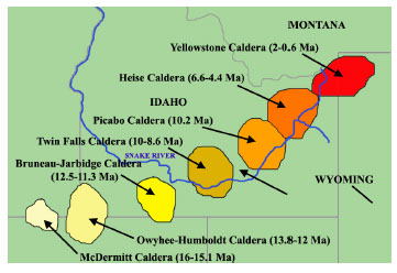 Another line of evidence is from topographic changes as a result of thermal uplift with the passage of the crust over the hot spot and then subsidence with cooling controlling the location of the Continental Divide. A topographic high produced by the hotspot resulted in radial drainage systems that flowed away from the volcanic centre. In the Miocene, when Snake River Plain volcanism began, the continental divide was located west of its current position and local streams drained toward the Atlantic Ocean; sediments were transported eastward, northward and southward away from the location of the volcanic high. As the continental divide moved eastward across southern Idaho, rivers south of the Snake River Plain began to flow south and east. Subsidence in the wake of hotspot migration caused a drop in the base level of the Snake River Plain, which initiated headward erosion toward the modern Snake River channel. This eventually led to stream capture and the shift of drainage to the Pacific Ocean.
However there are some problems with the hot-spot model that links the Columbia basalts and the Snake  River Plain in that the Columbia Basalt vents do not lie along the track of the Yellowstone hot spot, as predicted by the absolute motion of the North American plate. The second is the spatial and temporal gap between the vents for the Columbia Basalt, which erupted mostly from near the Idaho-Oregon-Washington border between 17.2 and 14.5 Ma, and the western Snake River plain and Owyhee plateau lavas, which began erupting 250 to 480 km to the south at ~ 16 Ma. The prominent change in direction between the eastern and western portions is a further problem as the change is not explicable by changing motions of the North American plate.
The tectonic origin of the Snake River plain is also problematic because it lies at the boundary of several major tectonic provinces. One possibility is that the structural alignment marks the transform-like northern boundary of the Basin and Range province. The main problem with this model is that the eastern Snake River plain clearly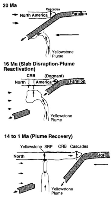 crosscuts extensional Basin and Range structures, some of which were extending prior to the arrival of the hot spot. In particular, there is no sign of the hot-spot track west of the Owyhee plateau and western Snake River plain. Furthermore, the ages of lavas indicate that volcanism has transgressed at a rate of 4.5 cm/yr, which is at odds with the 1.1 cm/yr rate at which the North American plate has been drifting in the hot-spot reference frame.
Tomographic seismic imaging of the mantle beneath the NW USA region has provided evidence of how the Columbia Basalts and the Snake River Plain may indeed be part of one plume system. The imaging shows that the present subducting Juan de Fuca plate dips steeply at 60 to 80° beneath the continent, but appears to end at ~300 km depth. What appears to be the remnant of the older Farallon plate dips shallowly further to the east, and the contrast in dips suggests that the Farallon plate may no longer be connected to the actively subducting Juan de Fuca plate. This model envisages that the Yellowstone plume was initiated at ~ 20 Ma but its upward movement was constrained by the cold subducting Farallon slab. This constraining led to a pooling and deflection of the uprising mantle in the direction of the subducting plate, which at this period was towards 027°. Eventually the uprising thermal anomaly of the plume weakened the slab causing it to rupture, with a slowing or temporary halt in subduction, which is recorded by a hiatus in the Miocene “Cascade” volcanism at this period. The rupture of the plate (now seen by the dipCross section of the North West USA, seen from the North difference in the seismic imaging), then allowed the plume to recover in a near vertical uprise in a position controlled by the movement of the North American continental plate, rather than being deflected by the subducting Farallon plate.
CRATERS OF THE MOON
Here are some details of geological features to be seen in the National Monument.
Craters of the Moon is a large (620 sq mile) lava field with cinder cones, spatter cones, lava tubes, volcanic bombs and tree moulds. It is the largest mostly Holocene-aged basaltic lava field in the contiguous United States. The 60 distinct solidified lava flows that form the Craters of the Moon Lava Field range in age from 15,000 to just 2,000 years. This lava field is the largest of several large beds of lava that erupted from the 53-mile south-east to north-west trending eastern Snake River Plain.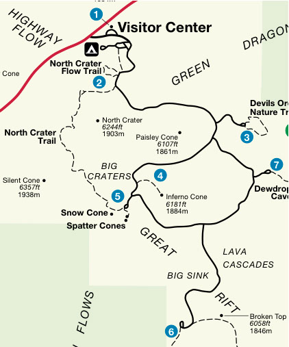
Visitor centre- North Crater trail (0.3 mile)
Stop 1 Pahoehoe Lava Pahoehoe at Craters of the Moon was very viscous or thick and was very close to being aa. Even in large channels this thick lava was probably only flowing at 3-6 miles per hour.
Stop 2A Triple Twist Tree A core sample taken from the triple twist tree, showed it to be at least 1,350 years old, and so the lava is older.
Stop 2B Pressure Ridges and Squeeze Ups Pressure ridges are a common feature of pahoehoe flows. They form as the flow's crust is pushed upwards by the pressure of the moving lava beneath. The arched crust generally cracks open, and may allow molten lava to "squeeze up" to the surface like toothpaste out of a tube. Pressure ridges are usually a few feet high and about 100 feet long, but they can be as high as 50 feet and over half a mile long.
Stop 3 Aa Lava Most lava flows emerge as pahoehoe and somewhere downslope change into aa as the lava cools, loses much of its gas, and becomes thicker. As the flow cools, it begins to slow down, moving as a mass of broken rubble. An advancing aa flow moves like a giant, slow moving tank or conveyer belt. Cooling lava rock that slides down the front of the flow is overridden by the advancing mass.
Stop 4 Blue Dragon Lava Blue dragon is one of the youngest and largest lava flows in the park, the name coming from a thin outer layer of lava that contains titanium magnetite crystals.
Stop 5 Rafted Blocks Rafted blocks, or monoliths, are sections of a broken crater wall that have been carried along on top of an aa lava flow which are thick enough to "float" the blocks.
Stop 6 Block Lava Block lava is a variety of aa lava characterized by large irregular blocks of lava with smooth surfaces. Block flows are thicker than aa or pahoehoe, and when they are molten, they creep along at very slow speeds.
Big Craters and Spatter Cones
The Spatter cones are located directly off the parking area. Big craters is a steep 1/4 mile long paved trail to the crater's rim. Big Craters is actually a "cinder cone complex" consisting of nine nested cones made up of brown, red, and black cinders.
Stop 1 Fissure-Type Eruptions (Halfway to the top of Big Craters) Initial eruptions begin as a fissure opens, erupting a very fluid lava charged with gas giving rise to a "curtain of fire." As the eruption continues, sections of the fissure begin to seal off and all of the force of the eruption directed into one opening, creating a fire fountain hundreds of feet high. Cinder cones are formed as cinders pile up around such a vent.
Stop 2 Big Craters Big Craters is a great example of how a fissure eruption gradually changes from a long curtain of fire to a single main vent. The fissure beneath Big Craters probably extended from the Spatter Cones to North Crater. Eruptions took place at many different points along the fissure. Big Craters is called a "cinder cone complex" because it's made up of as many as nine separate vents. Some of the smaller vents sit inside of larger ones. The cinders that make up Big Craters are varying
Stop 3 Spatter Cones These "miniature" volcanoes form during the final stages of a fissure type eruption. As gases escape and pressure is released, the lava becomes thick and pasty. When these sticky globs of lava plop to the surface, they pile up to form spatter cones. Most spatter cones are much smaller than cinder cones. They are rarely more than 50 feet high.
The Broken Top Loop Trail is one of the most outstanding trails within Craters of the Moon.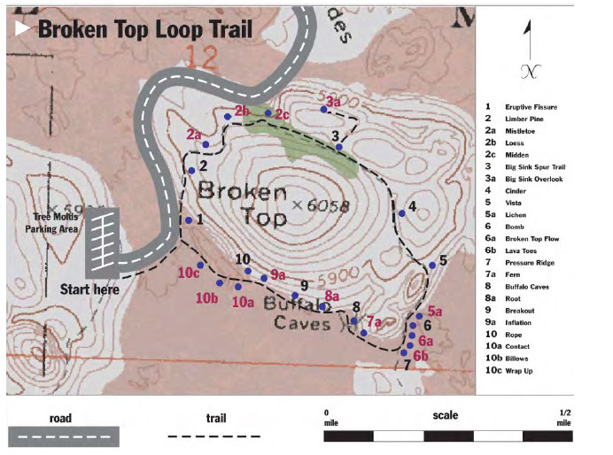 Along its 2-mile length you can observe nearly every type of volcanic feature characteristic of the basaltic eruptions that created this unearthly landscape. Buffalo caves are a series of lava tubes with lava curbs marking the previous height of lava within the tube. If you wish to explore Buffalo Cave, a flashlight is needed and watch your head.
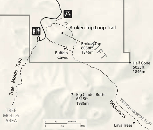
Lying south of Broken Top is the Big Cinder Butte is about 6,000 years old, and at more than a mile in diameter is one of the largest cinder cones in the world, At over 7,00’ high the fire fountain from it would have been in the order of 1,500’. It is asymmetric to the NE because of prevailing winds.
 Tree moulds loop (2 miles round trip) winds through shrubs and stands of limber pine before reaching the edge of the Blue Dragon Flow. While still molten, this lava flow knocked down and ignited trees. The charred tree trunks left impressions on the lava rock. In some places, the trees remained standing as the lava encased them, leaving vertical moulds in the cooling lava.
May 29th to June 11th 2016