WEGA in the North West United States
Return to "Day" page
Return to Day 9 Page
Geological Background
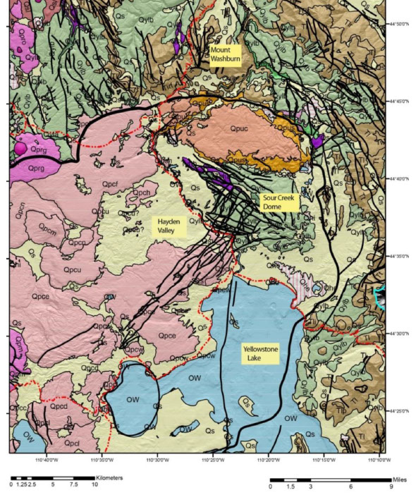
The route south is along the Hayden Valley, which is in the northeastern parts of the Island Park and Yellowstone Calderas. The raised area to the east of the valley is the Sour Creek dome, one of the sites of the last eruption some 600,000 years ago. Between 1923 and 1985, this dome was resurgent, rising at ~ 1” per annum, but since 1986 it has either declined or remained static. The dome resurgence has caused Yellowstone Lake to “tilt” southward so that larger sandy beaches are developed on the north shore.
Mud Volcano and Sulphur Caldron: Temperature 184°F Dimensions 27x36 feet. Depth 17 feet. Mud Volcano is a bubbling, seething spring, and the area has an abundance of pungent smells from the sulphur emitted by the mud pots and mud volcanoes. Mud Volcano Area, also known for Black Dragon's Caldron, Sour Lake, Mud Caldron, Dragon's Mouth Spring, and Sulphur Caldron, is very acidic (pH 1.2), and the growth of a specific bacterium has produced a yellow-coloured spring which contrasts to the other dark-gray or black, springs.
Dragon’s Mouth: Temperature 170.2°F Dimensions 18x30 feet. Depth 16 feet. Dragon's Mouth is a turbulent hot spring with a cavernous mouth. Water sloshes rhythmically in and out of the cavern giving the impression of a large overflow; however, the actual discharge is quite small. As hot water rises to the surface, hydrogen sulphide, carbon dioxide, and water vapour gases expand creating a pressure explosion in the cavern. The resulting activity is sloshing, belching, and steaming.
Also, along this drive note the flat terraces in the hillside – these are former lake shore terraces, indicating a period of time when Yellowstone Lake was much higher.
WEST THUMB GEYSER BASIN is a caldera within a caldera, which formed as a result of a relatively small eruption and subsequent caldera collapse about 150,000 years ago. This thermal area exhibits occasional geyser eruptions, but most of the thermal features are deep, steep sided conical pools of hot (sub-boiling to boiling) water formed by small hydrothermal explosions. There are also some mud pots located here at slightly higher elevations. There are active hot vents located off shore for several hundred metres, which keeps a zone of warm water along the shore here that never freezes in winter. One of the vents is called the “trout Jacuzzi” due to the abundance of cutthroat trout that feed on thriving populations of amphopods and bacteria.
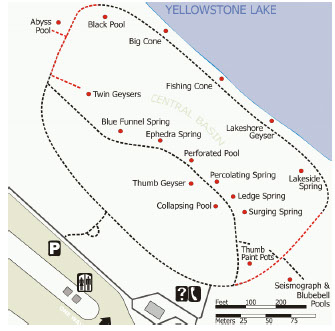
West Thumb Geyser Basin is one of the smallest geyser basins in Yellowstone yet its location along the shore of Yellow-stone Lake ranks it as the most scenic. West Thumb derived its name from the thumb-like projection of Yellowstone Lake.
Fishing Cone: Temperature 170.4°F Interval dormant. Duration minutes to hours. Height 3 feet. Fishing Cone is a thermal feature unique to Yellowstone. It is situated on the shore of Yellowstone Lake and received its name from early explorers who stood on the cone and cast their lines into the lake to catch fish. Without taking the fish off the hook they parboiled them in the vent of Fishing Cone.
Abyss Pool: Temperature 172°F Dimensions 30x57 feet. Depth 53 feet. Abyss Pool is a colourful and the deepest pool known in Yellowstone and received its name for its abyss- like depth. The dark green-coloured water gives the illusion of a bottomless pool. Vandalism may have changed this pool's temperature. Coins and other debris thrown in have caused the vent to plug. The reduced spring flow also reduced the pool temperature, allowing abundant algae growth along the edge and run-off channels. The extensive microbial mats now support ephydrid flies, spiders and killdeers.
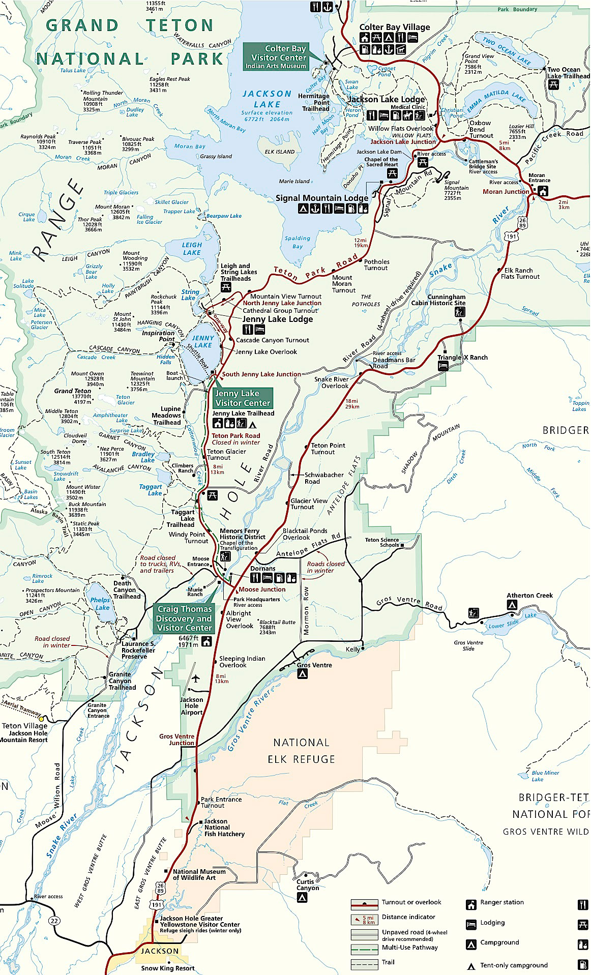
The route south along SR 191 is across the Yellowstone caldera, and reaching Lewis Lake the road for a short distance is along the caldera margin. From the northern tip of Jackson Lake, the route passes off the Yellowstone Plateau and into the Central Rocky Mt province, which is dominated here by the Teton Mts.
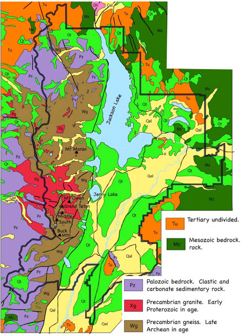
The Tetons are an upthrown fault block of late Archean crystalline rocks overlain by westward dipping Palaeozoic sedimentary rocks. A ~ N-S fault extends 40 miles along the base of the range, where it is faulted against Palaeozoic – Tertiary sedimentary and volcanic rocks. At 13,770’ the summit of the Grand Teton rises 7,000’ above the valley floor. Vertical displacement across this fault may be up to 30,000’, as shown by the Flathead Sandstone which caps Mt Moran 6,000’ above the valley floor and its equivalent is buried more than 20,000’ beneath the valley floor. The valley is covered by flood plain alluvium, which is glacial-outwash material that has been reworked by modern streams.
The Teton fault is a young feature and displaces Laramide age structures, and movement started ~ 6 – 9 Ma, with an uplift rate of ~ 2mm/year. The N-S orientation of the fault parallels other Basin and Range faults suggesting that it is related to Tertiary extensional development. Its position lies at the very northern extent of the Basin and Range area, so accounting for the young age of the fault. It is also suggested that the igneous activity linked to the Yellowstone plume will have added to the Basin and Range extension by arching of the crust adding to the tensional forces. The best view of the Teton fault is from the Cathedral Group Turnout along the Jenny Lake Scenic Loop. At the Leigh and String Lake Trailhead, to the west is the Rockchuck Peak fault scarp with a height of ~ 60’ and is thought to have formed ~ 15 Ka.
Moose-Wilson Road follows the contours of moraines. It is a good section to look for elk, moose, beaver, and waterfowl inhabiting the many ponds.
Kelly Loop/Antelope Flats includes many historical homesteads and early ranches. Signs of their old irrigation ditches, hayfields, and buildings remain. The southern portion follows the Gros Ventre River, where bald eagles and moose are seen year-round, and it borders the National Elk Refuge for a few miles. Large herds of migrating elk cross the road during their spring and fall migrations. Out on the sagebrush flats is the best place for finding bison and pronghorns, especially on the northern part of the loop across Antelope Flats. In early summer, bison calves are easy to see, but pronghorn fawns are more difficult to observe. Moose, deer, coyotes, and badgers inhabit the area.
Moran Junction to Jackson Lake Junction one of the richest wildlife areas of the park at dawn or dusk. Oxbow Bend and the Snake River just below Jackson Lake Dam, offer a chance to see wildlife most times of the day. Oxbow Bend, an old channel of the Snake River produces frequent sightings of moose, trumpeter swans, American white pelicans, ospreys, bald eagles, and river otters. The willow thickets near Jackson Lake Junction form a favourite haunt of bull moose most of the summer and fall months. Two nearby spots, Christian Pond and Willow Flats, may have wildlife present any time of day.
Signal Mountain Summit Road passes through lush huckleberry patches where black bears feed, and by a meadow and pond favoured by moose. Mule deer inhabit the open forest along the lower stretch of road, making it a good place to see their fawns in early summer. Birds such as the western tanager, goshawk, and canada jay live in this pine forest. This road offers several turnouts with unsurpassed panoramic views of Grand Teton National Park.
The Gros Ventre Landslide (1925) left a scar on the north slope of Sheep Mt. Heavy rain caused bedding plane slip and the flow dammed the river, which later failed in 1927 and flooded the local villages of Kelly and Wilson.
Return to Day 9 Page
May 29th to June 11th 2016