Day 5 - Geological Background
More can be found HERE.
THE DEVONIAN MUDMOUNDS
Hamar Laghdad (Devonian mud mounds)
The mud mounds of Hamar laghdad are very impressive and beautiful geological structures (Figure P6). The locality lies about 20 km southeast of Erfoud. The Devonian sediments dip to the south presenting over fifty conical buildups of different sizes (Figure P7). The maximal height is 55 m. The first records are by Menchikoff (in Roch 1934) described as coral reefs.
The first geological description was by Massa et al. (1965).
Gendrot (1973) identified these structures as mud mounds and consequently became the subject of many analyses with the origin of the mounds still being debated (review in Brachert et al. 1992; Belka 1994, 1998; Buggisch and Krumm 2005; Joachimski et al. 1999; Mounji et al. 1998; Peckmann et al. 1999).
Recent interpretations of the mounds at Hamar Laghdad are in relation to submarine hydrothermal vents (Belka 1994, 1998; Mounji et al. 1998).
This is in contrast to most of the other mounds from the Devonian of North Africa, as they are interpreted to be of microbial character (Wendt 1993, Kaufman 1998). The debate about the origin and what cemented the mounds is still ongoing. Nevertheless the interpretation as submarine hydrothermal vents made this locality famous as an analogue for recent cold seeps and the fauna for studies about chemosynthetic communities.
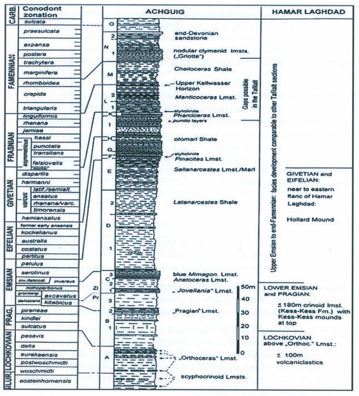
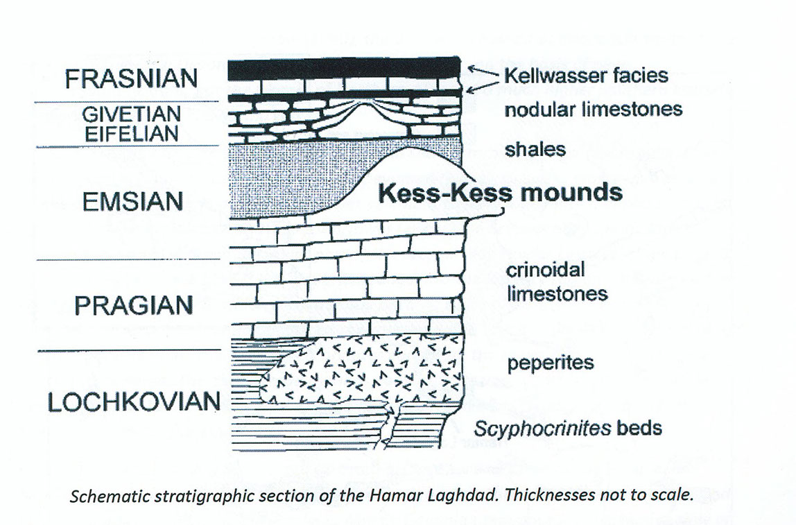
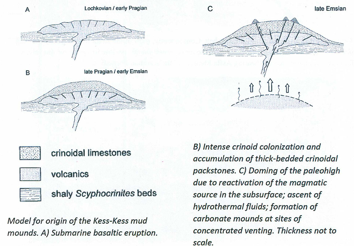
The mud mounds of Hamar Laghdad are located in the area of submarine volcanic activity at the beginning of the Devonian (Figure 8, Belka 1998). Sedimentation of crinoidal limestones (with a thickness of up to 180 m) covered the volcanic rocks, which are locally found as basalts and peperites. Along fault systems hydrothermal vents were remains of the volcanic activity (Figure 8C, Belka 1998). A slightly different model was proposed by Mounji et al. 1998
Most of the mounds are of Emsian age, but structures in the east of the outcrop are of Eifelian and Givetian age. Organisms associated to the mud mounds have been interpreted to represent hydrothermal vent communities (Belka and Berkowski 2005, Berkowski 2006, Cavalazzi et al. 2007).
Trilobites
Scutellum sp. and Barrandeops cf. granulops - extraordinary preservation as red trilobites with green eyes (Klug et al. 2009).
In Brief
Spectacular conical Early Devonian carbonate buildups up to 55 m high that crop out in the eastern Anti-Atlas of southern Morocco are microbially mediated carbonate mud mounds that were surfaced by soft-bottom communities dominated by small tabulate corals.
They formed on the Hamar Laghdad elevation, which was created by a submarine volcanic eruption, and
were associated with a network of synsedimentary radial and tangential faults that originated by uplift of the intrusive laccolithic body underlying the Kess-Kess Formation.
These faults served as conduits for the migration of hydrothermal fluids to the sea floor. Most mounds developed over cross-points of radial and tangential faults. Vents were episodically active until the Famennian, but extensive vent carbonate production occurred only during the Emsian. Preliminary geochemical results document that mudmound carbonates and calcite cements in neptunian dikes precipitated from brines comprising a mixture of hydrothermal fluids and seawater.
In addition, carbon isotope compositions (d13C as low as -18‰ PDB) suggest a contribution from thermogenic methane derived presumably from underlying basaltic intrusives. Aerobic bacterial oxidation of methane is favoured as the main process driving carbonate precipitation in, and rapid lithification of, the mounds.
Introduction
Mud mounds are the most common type of Devonian carbonate build ups. Once regarded as reefs sensu
lato, and having very few modern counterparts, these structures are often enigmatic because factors that controlled their growth can rarely be examined in modern environments. Since the term "mud mound" is used to describe carbonate buildups of various origins and structures, only a broad definition can be offered. Bosence and Bridges (1995) described them as "carbonate buildups having depositional relief and being composed dominantly of carbonate mud, peloidal mud, or micrite" . They recognized two basic types of mud
mounds: microbial and biodetrital. The variety and the commonly complex origin of these structures
are well displayed by examples documented by Monty et al. (1995).
Although less common than in the Devonian of Variscan Europe, mud mounds are among the most
spectacular features of the Devonian of North Africa. Both the Algerian Sahara and the Anti-Atlas provide a number of perfectly exhumed mounds that reveal their original morphology (see Brachert et al. 1992; Wendt 1993; Wendt et al. 1993; Wendt et al. 1997; Kaufmann 1996, 1997). Most appear to have a microbial character, but in a few cases evidence was found that mounds are related to submarine hydrothermal vents (Belka 1994 ). The best known are the Early Devonian mud mounds of the Hamar Laghdad in southern Morocco (Fig. 1). They are exposed about 16 km SE of Erfoud, where Devonian rocks dip gently to the south and form a topographic ramp in the present-day landscape.
Concentrated in a relatively small area, more than 40 cone-shaped mounds offer a magnificent landscape (Fig . 2). The Hamar Laghdad mounds were first reported by Menchikoff (in Roch 1934) and regarded as coral reefs.
Massa et al. (1965) provided the first detailed description of these structures. There is a broad
literature on both paleontological and geological aspects of the Hamar Laghdad mounds (for review
see Brachert et al. 1992).
Geological background
During much of the Palaeozoic, the eastern Anti-Atlas constituted a fragment of a broad shelf area expanding over the northern continental margin of the West African Craton . Its depositional and tectonic evolution was controlled by regional, E-W trending strike-slip faults. They influenced the subsidence pattern and occasionally acted as sites of volcanic eruptions (Belka et al. 1997). The progressive disintegration of the shelf in the Devonian led to the formation of a pronounced sea-floor relief with carbonate platforms and small intracratonic marine basins (Wendt 1988}. As a consequence, the Devonian sequence of the eastern Anti-Atlas is strongly differentiated with respect to facies and thickness. The paleogeographic position of the Anti-Atlas during the Devonian is still controversial.
According to Scotese and McKerrow (1990), the area was situated at about 40S south of the equator in the Early Devonian. Tait et al. (1995), however, on the basis of new palaeomagnetic data, put the margin of Northern Africa at a much higher southern latitude of approximately 60-70S during this time.
The Hamar Laghdad is one of three small areas in the eastern Anti-Atlas where submarine volcanic activity took place during the Early Devonian (Fig. 1). Basaltic, glassy lava erupted on the sea floor and amalgamated with wet sediment to form a peperite complex up to 100 m thick. Overlying the uppermost Silurian/lower Lochkovian Scyphocrinites beds, these volcaniclastic rocks built up the lower part of the present-day Hamar Laghdad ridge {Figs. 3, 4). According to Alberti {1982), the peperites range into the lowest Pragian. Their deposition created a submarine rise, which subsequently became a site of extensive crinoid colonization. As a result, crinoidal packstones accumulated to a maximum thickness of about 180 m
(Brachert et al. 1992). These carbonates constitute the lower part of the Kess-Kess Formation, whereas the conical mud mounds constitute its upper part (Fig. 3}. The name Kess-Kess refers to the conical shape of the mounds, resembling dishes used to cook the Moroccan national food couscous.
Conodonts, trilobites, and dacryoconarids support an Emsian age (inversus Zone) of the buildups. It was, however, still during the late Emsian when these structures were onlapped by calcareous clays (Fig. 3). The overlying Middle Devonian sequence is composed mainly of nodular cephalopod limestones. During that time the mound facies, comprising lenses of auloporid coral-rich boundstones, remained restricted to two small local occurrences in the eastern part of the Hamar Laghdad ridge (Brachert et al. 1992). Although the stratigraphic framework of this part of the section is not satisfactorily constrained, it is evident that the carbonate build ups disappeared in the entire Anti-Atlas region before deposition of the Lower Kellwasser Member in the Lower asymmetricus Zone (Wendt and Belka 1991; Kaufmann 1996).
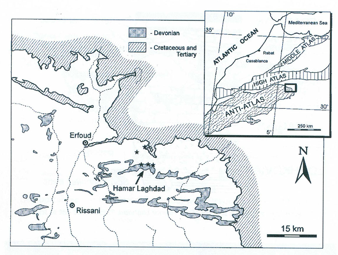
FIG. 1.- Simplified geologic map of the northeastem Anti-Atlas showing distribution of Devonian
rocks and location of the Hamar Laghdad area. Exposures of Lower Devonian volcanic rocks are
indicated with asterisks. Inset shows regional geology and location of the study area (modified
from Michard 1976).
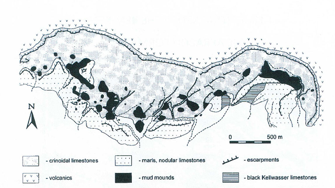
Geological map of the Hamar Laghdad, with Devonian Strata indicated.
Introduction
Arrival
Day 1
Day 2
Day 3
Day 4
Day 5
Day 6
Top of Page