Monday 26th August 2013
We found ourselves a powered site at the Fitzroy Crossing camp site and were much impressed with the facilities. I was able to do some work on my photos on the laptop.

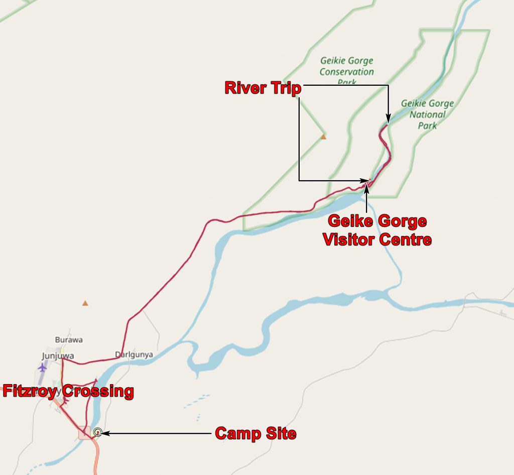
We got up early and set off for Geikie Gorge National Park.
The strange name comes from the Director of the British Geological survey in the 1880’s. Archibald Geikie never visited Australia, never mind Geikie Gorge. It was named by Edward Hardman, one of the first white men to see the gorge, who had previously worked for the Geological Survey of Ireland and who wanted to be the Western Australian Government Geologist.
I surmise that his naming of the gorge was an insurance policy. At that time the Irish Geological Survey was a sub-office of the British Geological survey. When the Western Australian Government refused to appoint a geologist at that time he returned to Ireland and got his old job back. I presume naming a marvellous geological feature after a possible boss did not do his prospects any harm!
But the poor man died shortly after re-starting with the Irish Survey. And he had applied for and got the Western Australian Government Geologist job – news of his death reached Perth shortly after it had been decided to offer him the job!
Moves are afoot to rename the gorge by its local aboriginal name – Darngku.
The first thing you notice when you get to the gorge is the visitor centre and signs indicating the various flood levels of the Fitzroy River. Indeed some of the recent floods have overtopped the building.

The Geike Gorge Visitor Centre in The Dry

Flood levels recorded in the Visitor Centre.
And when we set sail on the Fitzroy River we readily believed the claims of the flood levels. The gorge is cut in a Devonian reef – a coral reef except that abundant corals had not yet evolved. The responsible creatures were calcareous algae and coral-like stromatoporoids, There were some early corals but these were mostly solitary ones. The rocks therefore are almost entirely limestone and this weathers to a dark brown colour – except where it has been scoured clean by flowing water. The “tide mark” on the cliffs is rather high!

The “tide mark” of floods on the Fitzroy

A closer view of the “tide mark”.

The flood level of the Fitzroy River is shown by the top of the white limestone.
The freshly washed limestone shows fantastic shapes. It has been eroded and dissolved and looks wonderful.

The wonderful shapes of the Devonian reef limestone.
The National Park closes in the wet season as boating on the river would be rather unpleasant. Some of the wildlife would also find it unpleasant, especially the Fairy Martins who build their nests on the undersides of overhangs which become submerged in the wet. They have to get their young out of the nest before the first flood.

Fairy Martin nests, built of mud, on the underside of an overhang.
The other noticeable wildlife in the gorge are freshwater crocodiles. There are lots of them! These are the “nice” ones – a danger to fish, not to humans, although I still wouldn’t like to be nipped by one. The “bad” crocs are the Salties who see humans as lunch – we didn’t actually see a single one of these in all our time in Australia.

A Freshie resting at the base of the cliffs.

Another Freshie with its periscope eyes.
The trip along the gorge was good fun and we saw lots of cliffs, birds and their nests and lots of Freshies. And we saw Trickie Dickie Nixon!

In the wet of 2011 the water got up to Nixons nose!
Back in Fitzroy Crossing we paid my speeding fine at the Post Office – paying the fine was almost as easy as breaking the speed limit.
Then to the Crossing Hotel and saw a queue waiting for the bar to open! Most were aborigines. We looked at an Aboriginal Art exhibition at an adjacent gallery then bought some decorated boab nuts from an aboriginal gentleman sitting and working in the shade outside.

Bob the boab nut carver.
The application below shows you various .kmz files. If you open them with Google Earth you will get our route and the photographs I took, at the spot I took them, displayed in all their glory! Download the file you want, store it somewhere on your computer, open Google Earth and open the file.
[slickr-flickr tag=”26-08-13″]