We woke with the dawn and climbed a nearby sand dune to watch the early morning light strike the escarpment of the Kennedy Range. It was rather magical.

The escarpment of the Kennedy Range in the early morning light
Looking the other way we could see our camp site which also looked rather magical.

Camp life
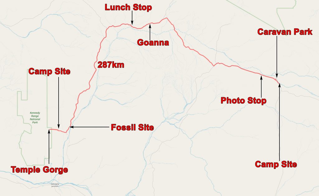
As our journey to Mount Augustus was shorter than previous days we decided to re-enter the National Park and have a look at Temple Gorge. Before leaving Perth we had bought a pass for all the National Parks in Western Australia so we could drive right in.
The Kennedy Ranges are a pile of Permian sediments, mostly of shallow marine origin. You can get a geological map of the area HERE. This will tell you more about the geology than I can and with infinitely more accuracy!!! They are of an age with the Karroo in South Africa and are similar to rocks in South America, Antarctica and India – part of the evidence for the ancient continent of Gondwanaland.
Like almost all the rocks we saw they are RED! This is due to desert varnish – occasionally the rocks get soaked by some rain, the water dissolves some salts, the most colourful of which is iron, the hot desert sun draws the water to the surface along with the iron, the water evaporates and the red iron is left on the surface.

Walking into Temple Gorge
The gorges are caused by erosion and this can be spectacular.

John demonstrates to Julie the contact of recent scree with Permian sandstone

Further into Temple Gorge
After having seen the rugged beauty of Temple Gorge we returned to our trucks and set off for Mount Augustus. But we did not go far before our first stop. This was just outside the park at a roadside site loaded with shallow water fossils – mainly crinoids (sea fans) and brachiopods (shellfish). According to the geological map, mentioned above, this is near the junction of the Carboniferous and the Permian – the Callytharra Formation of Sakmarian age.

The Permian fossil site

The 1:250,00- Geological Map of the Kennedy Ranges, with some localities and GPS tracks added.Click on the map and you will be transported to the map on Flickr.
The fossils indicate shallow sea water. Immediately below this is the Lyons Formation which is said to be glacigene. We did not get a chance to look at it but it is described (HERE) as being a tillite – that is a rock composed of stones dropped into the sea by melting icebergs. I have assumed that crinoids would be warm water fossils but perhaps they are hardier than I thought! The tillite is presumably the Australian equivalent of the Dwyka Tillite of South Africa.
We continued on our way, stopping at the side of the road for a picnic lunch.

Lunch stop
After lunch we continued, passing a cyclist who had a little trailer and was pedalling hard! He was about the only other road user we saw all day! However we did see a rather large goanna which deserved a photo.

A goanna
John was hoping to fill up at the settlement at Cobra but they no longer sold fuel. He would need to find fuel at Mount Augustus. Our 150 litre tank began to look even better.
Before long Mount Augustus came into view and our days driving was almost done.

Mount Augustus
We stopped at the Mount Augustus Caravan Park and found that they stopped selling fuel at 4PM. It was 30 minutes after that. This ploy is meant to ensure that people short of fuel, like John, would stay at the camp site until the pumps reopened the next day. This did not work in our case! We drove a few miles down the road and wild camped. We would come back the next day to fill up!
The application below shows you various .kmz files. If you open them with Google Earth you will get our route and the photographs I took, at the spot I took them, displayed in all their glory! Download the file you want, store it somewhere on your computer, open Google Earth and open the file.
[slickr-flickr tag=”12-08-13″]