Hancock Gorge and a peek at Joffre Gorge
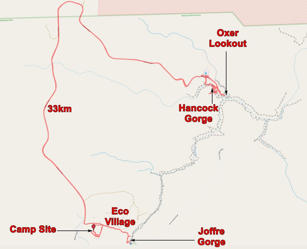
Today we did two gorges, Hancock in the morning and Joffre in the late afternoon. Hancock is close to Weano which we did yesterday and Joffre is within walking distance of our camp. The map below shows where we went and also that all the rocks we saw were Brockman Iron formation


Before descending into Hancock gorge we went to the Oxer lookout. This is near the place where four gorges meet. Weano, Hancock and Joffre combine to form Red Gorge and a little downstream, Knox Gorge joins.

The view from Oxer Lookout. We are perched above Hancock Gorge with Kermit’s Pool somewhere below us and behind us on the right. In front is the southern wall of Red Gorge with Joffre Gorge coming in on the right (where the light green water is). Weano Gorge enters opposite. Knox Gorge debouches into Red Gorge one kilometre further on, from the south. This photo has had to be digitally manipulated to lighten the shadows and darken the highlights – this needs to be done for many of the photos of Karijini Gorges.
After the lookout we started down into Hancock Gorge. At first this is just a steep path past red cliffs.

The path into Hancock Gorge.
But then you come to a steel ladder which takes you down a small cliff and you are on the bottom of the gorge.

Chris half way down the ladder into Hancock Gorge.
There is water in the bottom of Hancock Gorge. The stream is barely flowing but the stream’s course is so rugged that there are pools all along the gorge.

Pool in Hancock Gorge. The blue marker on the right indicates that this is a grade 4 or 5 trail.
But as you go downstream the trail becomes a little more tricky and your scrambling skills are tested.

Chris testing her scrambling skills. And just look at the Banded Iron formation!
The gorge becomes more constricted and the way more difficult.

The Hancock Gorge trail. Here its straightness indicates that the stream is controlled by jointing. Note the people at the top right.
And then you come to Kermit’s Pool which is where the tired traveller can refresh with a bracing dip.

Kermit’s Pool. The water is very cool. The sun seldom shines down here.
And just beyond the pool you come to signs telling you to go no further. The category of the trail changes from 4 or 5 to 6 and 7 and climbing aids and abseiling skills are required beyond this point. If you pay $A245 each you can go on tours from the Eco Resort with a climber who has the requisite gear for getting into the deeper gorges. He also supplements his income by rescuing people who get stuck in the gorges.

Chris at our furthest point in Hancock Gorge.
So we turned back and headed out, but not before one last backward glance.

Our last look down Hancock Gorge.
On our way out we paused to take some photos, Chris put down her camera and forgot to pick it up again! We never saw it again. I passed my spare camera on to her. After lunch back at the camp we rested and then set off to walk to Joffre Gorge. It was then that we discovered the loss of the camera, so our departure was rather delayed as we looked everywhere for it. It is an easy walk to Joffre Gorge, past the rather nice permanent tents of the Eco Camp. You can get into the higher levels of the Gorge easily but getting into the depths is rather more tricky.

Joffre Gorge in the early evening sun.
The low light of the setting sun lit up the higher parts of the gorge and these could be seen reflected in the water in the gorge bottom.

Evening light on the high gorge walls reflected in the pool in the depths of the gorge.
The moon was up and the sun was going down so we headed back to camp, determined to revisit Joffre Gorge on the morrow.

Moon over the Joffre Gorge Lookout.
The application below shows you various .kmz files. If you open them with Google Earth you will get our route and the photographs I took, at the spot I took them, displayed in all their glory! Download the file you want, store it somewhere on your computer, open Google Earth and open the file.
If you don’t have Google Earth you can get it HERE.
[slickr-flickr tag=”17-08-13″]