| Introduction | Windhoek | Okonjima | Okaukejo 1 | Onguma | Okaukejo 2 | Mowani |
| Swakopmund | Hoodia | Namtib | Fish River | Springbok | Babylon’s Toren | Going Home |
Our 40th wedding anniversary was coming up and we decided we needed to do something special and that something would be a holiday.
Where? I had always wanted to go to Namibia but had never managed to go there. Chris did her research and agreed that it would be a good place to go. And her research suggested that we should do it through Expert Africa. We did not regret this choice!
We also had a hankering to revisit the winelands near Cape Town and discussions with Sabina Hekandjo, Expert Africa’s person in Namibia, meant we soon had an itinerary worked out.

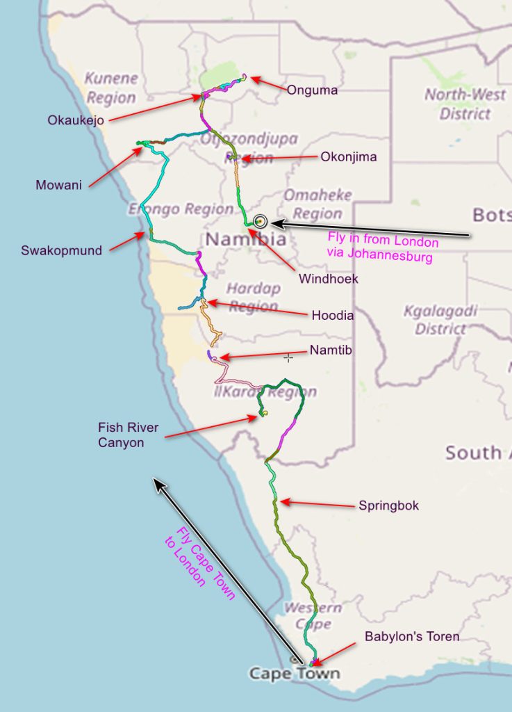
Our itinerary was:- Fly into Johannesburg, immediately fly to Windhoek, the capital of Namibia, drive northward to Onguma via Okonjima and Okaukejo, head west to Mowani calling at Okaukejo again. Then drive south to the Fish River via Swakopmund, Hoodia and Namtib. Cross into South Africa and head for Babylon’s Toren, staying overnight at Springbok. Finally catch a flight from Cape Town airport for the UK.
We could have done all our driving and navigating using the paper map given to us by Expert Africa – there are not many roads to choose from – but it was easier to use my GPS. I have a Garmin Montana 700 and I bought TOPO Southern Africa v7 Light for less than £20. I had to download it and put it onto a micro SD card which fitted into my GPS. Expert Africa give latitude and longitude co-ordinates for all the places we visited. Using Garmin Base Camp I uploaded the places to my GPS as waypoints and so, when travelling, I would find the waypoint we wanted to go to, press GO and eventually a route to our destination would appear.
Combined with a means of powering the GPS from the trucks cigarette lighter we could find our route easily. And we recorded our route – providing much of the information for the maps which follow.
The main content of these pages is photographs. You can find all my Namibian photos HERE and my South African ones HERE. Virtually all the photos are geo-referenced – you can find out where they were taken within a couple of metres. To do this, click on a photo. Near the photo you will find an “i”. Click on this and you will find a map showing the photos location.